West on Mass. Pike ( I-90). Stay on I-90 as you enter New York. When you come to the merge of I-87 and I-90, take exit B-1, follow I-90
northwards. In approx.15 miles you will cross the Hudson River Approx 6 miles after crossing Hudson, take exit 1 (I-87N) follow I-87 N Take exit 23 off of I-87 Left at end of exit ( Rt 418) Follow 418 for approx. 1 mile Turn right on to Rt 28 Follow for approx 36 miles to intersection with Rt 30 Turn right on to Rt 30 and follow for approx 45 miles to Tupper Lake
Turn right onto Rts 3 & 30 Bear left on Rt 30 (when 3 & 30 split) approx 6 miles Rollins Pond/Fish Creek State campground will be on your left
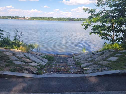
This is a DEM fishing access site with a gravel
parking lot and a concrete plank boat ramp providing access
to Alton Pond. The Alton fishing
access is a nice place to launch your kayak or canoe.
Driving Landmarks: The landing is right next
to Route 91 where it runs along the south end of Alton Pond
and over the Wood River, but to get to it by car you have to
turn onto Collins Road and then almost immediately turn onto
Woodville Alton Road and then turn into the parking lot.
(
It is a good take-out if you
are coming downstream on the Wood River, which flows through
Alton Pond. To continue downstream to the confluence with
the Pawcatuck River you will have to portage across Route 91
to get around the Alton Dam. The put-in below the dam is
informal and access is somewhat awkward because the access
is down the road embankment. Once on the water the paddle
downstream on the Wood and Pawcatuck Rivers is very scenic.
The river is not fast moving but there is some current and
some maneuvering is required.
It is about 0.7 miles to the junction with the Pawcatuck
River, and another 1 1/2 miles to the broken down dam at
Burdickville. The only egress here is on the right,
immediately upstream of the dam -- a short but awkward take
out up a steep, narrow path to Burdickville Road. You may
also lift over the left side of the dam, or you may run it
in the fast water right of center, close to the little
masonry "island." Only at high water should the dam be run
down the middle. A canoe camp, part of Burlingame Management
Area, is located on the left bank a mile downstream from
Burdickville. A RIDEM permit is required to camp at this
unsupervised camp with no facilities. Four more miles brings
you to Bradford. You can take out at the DEM landing ramp
and parking area on the left, or continue on to Potter
Hill Dam.)
source RI Blueways
We will put in at the Acton Canoe
Launch and paddle down the Assabet River to its convergence with the
Sudbury River to form the Concord River. This trip is mostly flatwater,
with some quickwater, and one broken dam at Damonmill that can be run or
portaged. We will continue down the Concord River the Old North Bridge in
the Minute Man National Historic Site.
Suitable for all boats and all
levels of experience.
Directions to the Put in: from I495
north, take old exit 27 toward Stow. Turn left onto MA-117 east.
Continue 7 miles and take left on to Main St. After 1 mile take a
right on the Waltham Street. After 500 feet take a left onto Powder
Mill Rd (MA-62 east). Continue for 1.2 miles. The Acton Canoe
Launch is on the right just before the bridge. 42°26'26.1"N
71°25'46.9"W
(Take out - Old Calf Pasture, 181 Lowell Road, Concord, MA )
The Bass river is the longest river on the Cape.
Archaeological evidence links the Bass River with a visit by Leif
Ericksson around A.D. 1000. Excavations in a gully along the pond
turned up evidence of what might have been a Norse boat shed. A few
boulders with holes resembling Norse mooring holes were found in the pond.
This will be a 10 mile paddle and the current should be
with us - up the river and back to the put-in. There is a short
stretch of quick water with a stiff current under the bridges into
Kelley's Bay.
To get to the put-in (which is Cove Road Landing) from
US 6, take exit 9A. Turn onto MA 134 south and drive .07 mile, then
make a right onto Upper County Road {3rd traffic light}. In 0.2 mile
turn left onto Main Street. Drive 0.6 mile and turn right onto Cove
Road. Go 0.6 mile to the town landing.
__________
Belleville Pond
North Kingstown, RI 41° 33.628' N 71° 28.543' W
Belleville Pond is
a 108 acre pond with largely forested and often marshy shorelines. The
shallow waters make the pond highly productive biologically,
which in
turn makes it attractive to wildlife and especially birds, however there
have also been recent problems with high phosphorus levels in the pond,
which can create excessive algae growth in the summer. There are many
coves and islands explore in a small boat. The boat ramp is at Ryan
Park, a
North Kingstown town park. There is a parking lot at the boat
ramp and the ramp itself is just the natural gravel shoreline of the
pond. From the boat ramp,
head northwest to find the narrow passage
(with a bridge over it) that leads to the main body of the pond. Only
non-motorized boats and boats with electric
motors are permitted and the
extensive vegetation growing in the pond would make it hard to use
motors anyway.
This site provides access to the
following water bodies in the Coastal Watersheds (West Bay) watershed:
Belleville Pond. Location: Alternate
Site Name: Ryan Park Town: North Kingstown
This will be a short, slow paddle around the pond, and we will poke into
multiple little bays and inlets to explore. We'll likely see ducks,
geese and herons. Near the end of our circumnavigation, if we're lucky,
we may see alewives still coming up the fish ladder at the dam.
If you want to bring a lunch or a snack, we will probably wait until we
return to the launch since this is a short paddle.
Driving Landmarks: From Route 4 take Exit 2A and go east on Route
102 for 2.6 miles, then turn south on Route 1. Go 0.8 miles on Route 1
and turn
right onto Oak Hill Road. The boat ramp is in Ryan Park, which
is 0.6 miles ahead on the right. Stay left on the loop road and follow
the signs in the
park to find the boat ramp.
Trip is not suitable for kayaks over 15 feet. Narrow and twisty
river. Paddle upstream against the current and then return with the
current to the put-in.
Johnson's Pond is a beautiful pond . The Big River is
also accessed at this put-in.
Trip is not suitable for kayaks over 15 feet.
Narrow and twisty river. Paddle upstream against the current and then
return with the
current to the put-in. The river gets smaller and smaller
winding through the woods over beaver dams.
Heading upstream from Route 3 you are heading
into the heart of the 8600 acre Big River Management Area. Be prepared
for lots of twisting and turning because the river follows a very
meandering course. At times the main channel can be hard to follow
because of the many dead end side channels that branch off. These
challenges, combined with the fact that you are paddling upstream and
likely to encounter beaver dams, makes this an energetic paddle..
The reward is getting to explore a beautiful
natural area, but inexperienced paddlers may get frustrated before they
get very far. Much of the area is low and marshy but the river
occasionally swings close to higher ground. If the water level is
good and the channel not too overwhelmed by vegetation you can go about
2 3/4 miles beyond Route 3 to where Nooseneck River comes in from the
west. Shortly beyond here both Nooseneck River and Big River get too
narrow to be paddleable.
Directions from 95 South.. Take exit 6 To Rt. 3 north
( DO NOT take exit 6-A which is Hopkins Hill Road) Take a right at the bottom
of the exit and
follow 3 North for about a mile and a half. Take a left onto
Harkney Hill Road. Follow for a little over a mile and look for the access
for Zekes Bridge.
Directions from 95 North, Take exit 6 to Rt. 3 north.
( DO NOT take exit 6-A which is Hopkins Hill Road) Take a left at the bottom
of the exit and
follow 3 North for about a mile and a half. Take a left onto
Harkney Hill Road. Follow for a little over a mile and look for the access
for Zekes Bridge.
Kelly House
Museum:1075 Lower River
Road, Lincoln, RI
Blackstone River State Park
entrance:65 Front Street, Lincoln, RI
This loop paddle travels the Blackstone
River and the Blackstone River Canal with a portage connecting the two.The loop can be traveled in either direction, starting in the
Blackstone River at the Kelly House Museum and going south, or starting
in the Blackstone Canal at the Blackstone River State Park and paddling
north.For a preview of the
trip, click on
https://vimeo.com/43746062
for a recording of Erik Eckilson’s solo 2012 paddle.
Exiting
the canal near the Kelly House can be difficult because the dock at that
location is damaged.Another
takeout is 100 yards further north at the base of the Ashton Viaduct
support column.The river
can be entered either behind the Kelly House or 100 yards north of the
viaduct down a flight of stone steps.
This trip is
suitable for boats 15 feet and under and for people with good boat
control. Paddling the
Blackstone River stretch between Ashton Dam and the Pratt Dam is
easier if the river is low; it can be challenging when the river runs
high. Quickwater conditions south
of the Martin Street Bridge require skill and are best left to those
with some rapids experience. Avoid
the orange buoys strung across the river above the Pratt Dam, the site
of several recent incidents and a 2008 fatality.The river take-out is to the right just after the buoys.It’s advisable to check beforehand if the paddle will be hindered
by any fallen trees blocking the canal.
Directions to the Blackstone River State Park Bikeway from Route 1
In Rhode Island, travel north or
south on Route 146 toward Lincoln.
Take Exit 5 in Lincoln for Route
123, Breakneck Hill Road.
If northbound from Providence, go
right at the end of the ramp for Route 123 East.
If southbound from Woonsocket, go
left at the end of the ramp for Route 123 East.
Go a total of 2.3 miles on Route
123.(Breakneck Hill Road
becomes Front Street.)
Continue a short distance
downhill after the Lincoln Shopping Center on the right.
Turn left at the Blackstone River
State Park/Bikeway sign.
Proceed down the road.
Enter the first parking lot on
the right.
Transport your boat to the end of
the road.
There are two small put-in areas
at each end of the bridge over the canal.
.........
Directions
to the Blackstone River State Park Bikeway from Route I-295
From Route I-295 North or South
toward Lincoln in Rhode Island.
In Lincoln, take Exit 18A for
Route 146 South.
Follow 146 South for about 3
miles to Exit 5 for Route 123, Breakneck Hill Road
Turn left at the end of the ramp
for Route 123 East.
Go a total of 2.3 miles.Breakneck Hill Road becomes Front Street.
Continue a short distance
downhill after the Lincoln Shopping Center on the right.
Turn left at the Blackstone River
State Park/Bikeway sign.
Proceed down the road.
Enter the first parking lot on
the right.
Transport your boat to the end of
the road.
There are two small put-in spots,
one at each end of the bridge over the canal.
Directions to the Kelly House
Museum from Route 146
From Providence, travel on Route
146 North toward Lincoln.
Take Exit 7 for Lincoln,
Smithfield, Route 116.
At the end of the ramp, turn left
onto George Washington Highway North, Route 116.
At the third traffic signal, turn
right for Route 126 South, Old River Road.
Immediately turn left again to
stay on Old River Road, Route 126 South.
Drive 1/2 mile on Old River Road
Right after the yellow water tower on the right, turn left onto
Cullen Hill Road.
Drive downhill to the end of Cullen Hill Road.
Turn left onto Lower River Road.
Follow Lower River Road to the end and turn right.
Park underneath the Route 116 Ashton Viaduct.
From Woonsocket, travel on Route
146 South toward Lincoln.
After Route 99 merges with Route
146 South, stay right.
Merge right onto the service road
for Exits 8a, 8b and 7.
Follow the service road to the
end and take Exit 7 for Lincoln, Route 116.
At the end of the ramp, turn left
onto George Washington Highway North, Route 116.
At the fourth traffic signal,
turn right for Route 126 South, Old River Road.
Immediately turn left again to
stay on Old River Road, Route 126 South.
Drive 1/2 mile on Old River Road
Right after the yellow water tower on the
right, turn left onto Cullen Hill Road.
Drive downhill to the end of Cullen Hill Road.
Turn left onto Lower River Road.
Follow Lower River Road to the end and turn
right.
Park underneath the Route 116 Ashton Viaduct.
Directions to the Kelly House Museum from Route I-295
From Massachusetts, take Route
I-295 South into Rhode Island to Exit 20.
Turn left at the traffic light
onto Mendon Road, Route 122 South.
Turn right at the second traffic
light onto Route 116 South, George Washington Highway.
From Rhode Island and Route I-295
North take Exit 20.
At the end of the exit ramp, turn
left onto Mendon Road, Route 122 South.
At the first traffic light, turn
right onto Route 116 South, George Washington Highway.
Once on the Wahington Highway,
drive less than one mile to the top of the hill.
Turn left at the traffic light
for Old River Road, Route 126 South.
Immediately turn left again to
stay on Old River Road, Route 126 South.
Drive 1/2 mile and take the first left after
the yellow water tower for Cullen Hill Road.
At the end of Cullen Hill Road, turn left onto
Lower River Road.
Follow Lower River Road to the end and turn
right. Park underneath the Route 116 Ashton Viaduct.
A fun, scenic paddle along the bike path in
Lincoln. This trip is
suitable for everyone.
Suitable for all boats and levels of experience. Put-in above
the Albion Dam and paddle upstream to the Manville Dam and back.
Directions
From 295N Take Exit 10 – Route 122 – Cumberland Take a right at end of ramp Proceed approximately .4 miles Take a left on to Albion Road – look for a CVS on the corner Proceed approximately .7 miles. You will see a sign for the Blackstone
River State Park on the right. Additional parking is available across the
street. Put in is located up the bike path about 100 feet.
From 295N Take Exit 10 – Route 122 – Cumberland Take a right at end of ramp Proceed approximately .1 miles Take a left on to Albion Road – look for a CVS on the corner Proceed approximately .7 miles. You will see a sign for the Blackstone
River State Park on the right. Additional parking is available across the
street. Put in is located up the Bike Path about 100 feet.
Directions
From I-95 Northbound or Southbound in Massachusetts:
Take Exit 4 in Massachusetts for Route I-295
south.
From I-295 South in Rhode Island, take Exit 20
and turn right onto Mendon Road, Route 122 north. Go north about
2 miles and turn left at the traffic light at Poppy’s Restaurant onto
Manville Hill Road.
At the bottom of Manville Hill Road, at the traffic light after the
Blackstone River bridge, turn left onto New River Road.
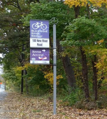
Go about 1000 feet on New River Road and take the first left at the Bike
Path/River Access sign. Proceed down the hill and cross the
railroad track. Park in the Manville Bike Path Parking Area in
front of the Blackstone River Watershed Council building.
The river launch area is down the path to the left of the council
building.
From Route I-295 Northbound in Rhode Island:
From I-295 North in Rhode Island, take Exit 20
and bear right onto Mendon Road, Route 122 north. Go north about 2
miles and turn left at the traffic light at Poppy’s Restaurant onto
Manville Hill Road.
At the bottom of Manville Hill Road, at the traffic light after the
Blackstone River bridge, turn left onto New River Road.
Go about 1000 feet on New River Road and take the first left at the Bike
Path/River Access sign. Proceed down the hill and cross the
railroad track. Park in the Manville Bike Path Parking Area in
front of the Blackstone River Watershed Council building.
The river launch area is down the path to the left of the council
building.
From Rhode Island Route 146 Southbound
from Massachusetts:
At the only Route 146 traffic light in Rhode
Island, soon after the 10-mile marker, turn left onto Sayles Hill Road.
(Expect heavy construction here through 2024.)
From Rhode Island Route 146 Northbound
from Providence:
At the only Route 146 traffic light in Rhode
Island, soon after the 9-mile marker, turn right onto Sayles Hill Road.
(Expect heavy construction here through 2024.) Follow Sayles
Hill Road down the hill and proceed under the Route 99 bridge. A
half mile later at the yellow blinker, bear right. Sayles Hill
Road becomes Route 126 South, Old River Road. Go one half mile
more and take the fifth left onto Main Street. At the traffic
light at the bottom of Main Street, turn right onto New River Road.
(Don’t cross the Blackstone River bridge into Cumberland.)
Go about 1000 feet on New River Road and take
the first left at the Bike Path/River Access sign. Proceed a
short distance and cross the railroad track. Park in the Manville
Bike Path Parking Area in front of the Blackstone River Watershed
Council building.
The river launch area is down the path to the left of the council
building.
Chocolateville Landing –
Central Falls We will put in at the
Chocolateville Landing
and paddle up to Valley Falls.
This is a pretty section of
the Blackstone River that
rarely gets paddled. The
put-in is on Charles Street at
the intersection with
Roosevelt Avenue (37 Charles
Street, Central Falls, RI
41.888221, -71.3822850).
From 95 North, take Exit 30
toward East Street/Central
Falls. Merge on to Fountain
Street. Turn left on to East
Street. Turn left on
to Roosevelt Avenue. Turn
right on to Charles Street
just after the bridge.
From 95 South, take Exit 30
for Roosevelt Avenue toward
Central Falls. Merge on to
Middle Street, and take a
quick right on to Roosevelt
Avenue. Turn right on to
Charles Street just after the
bridge.
There is a
pull-off for unloading boats
that will hold 2 or 3 cars,
but there is NO other parking
at the put-in. You will need
to move your car after
unloading and find on-street
parking in the neighborhood
nearby. That will result in
a walk of at least a couple of
blocks.
After unloading we
will have to have folks
move their cars so others
can pull in. There is no
on-street parking near
the
put-in on Charles Street
or Roosevelt Avenue, so
people will need to go up
about a block and park on
a side street.
From the North (Massachusetts, Worcester Area) Go
to Route 146 South. In Rhode Island, take Exit 14 for Forestdale/North
Smithfield. Turn left off the exit ramp and cross over the highway
bridge.
Go straight through the traffic light for Great Road, Route 146A south.
Follow Great Road, Route 146A straight to the next traffic light.
Turn left onto St. Paul Street. Follow St. Paul Street to the traffic
light at the end. Turn left onto Route 122 north, Main Street,
Blackstone Mass. Follow Rt. 122 north for about 1 mile. A sign will
direct you to turn left onto County Street towards the Blackstone Gorge. The
gorge is at the end of County Street with parking on the left.
From the South (Rhode Island and the Providence
Area)
Go to Route 146 North.
While still in Rhode Island, take Exit 14 for Forestdale/North
Smithfield.
Turn right at the end of the exit ramp. Take
an immediate right at the traffic light onto Route 146A South, Great
Road. Follow Great Road straight to the next traffic light.
Turn left onto St. Paul Street. Follow St. Paul Street to the traffic
light at the end. Turn
left onto Route 122, Main Street North in Blackstone Mass. Follow Rt. 122 North for about 1
mile. A sign will direct
you to turn left onto County Street towards the Blackstone Gorge.
The gorge is at the end of County Street with parking on the left.
Directions to starting site: From 146, take Exit for Route 16 East. Travel approximately 3 miles through Downtown Uxbridge, continuing on Rt.16
East. After passing St. Mary's Church on your right,
look for an old wood
and brick building on your left (Stanley Woolen Mill). Park on your right,
just over a bridge and just past the mill.
We will be shuttling vehicles and
boats as part of this trip. After dropping off boats shuttle vehicles
to route 122 in South Uxbridge.
The parking lot is on the
left just past Susan Parkway, just before a bridge.
South Uxbridge Drive Inn to Blackstone Gorge, Uxbridge
MA shuttle
Class II rapid on this trip.
Driving directions to the Uxbridge drive in
(which is now a storage facility): From the north: Take route 146 South. As you head south you will see one
exit that says 146A Chockalog Rd. , but don’t take that one,
go one more,
take the 146A exit that has a sign for McDonalds and reads 146A North
Smithfield. (If you stay on 146 and go too far you
will cross the into the
Rhode Island border. Turn around and follow the south directions). At the
end of the exit ramp turn right and go
underneath the highway, you should see McDonald’s on your right. Pass McDonald’s and watch on your right
for a small green sign that says "Balm of Life Spring" and a
large sign that
says Drive-In. If you get to Ironstone street you have gone too far on 146
A. Turn right on Balm of Life Spring road, turn left immediately after you pass the Drive-In Movie Screen and drive down the
gravel lane. Watch on your right for the parking area filled with cars and boats. From the south: Take route 146 North. Cross from Rhode Island
into Massachusetts, the first exit in Mass says 146A and has a sign
for
McDonalds. ( If you get to the 146A Chockalog Rd. exit you have gone one
exit too far.) At the bottom of the ramp, take a left onto 146A. Watch on your right for a
small green sign that says "Balm of Life Spring" and a large sign that
says
Drive in. (If you get to Ironstone street you have gone too far on 146 A.)
Turn right onto Balm of Life Spring road, then make a left immediately after you pass Drive-In Movie Screen and drive down the gravel lane, watch on your right for the parking area filled with cars and boats.
A 4-mile trip with one portage. Put in at the Ashton Dam in
Lincoln and take out at the Valley Falls Landing in Central Falls with a
portage around the Pratt Dam. The section from Ashton to the Pratt Dam
(2 miles) requires good boat handling skills – there are sections of moving
water and S-curves. The section from the Pratt Dam to Valley Falls (2
miles) is flat-water. This trip is suitable for shorter boats (15 feet and
under) and for people with good boat control.
Directions:
146 North or South to the Exit for Rt. 116 North. (Albion-Ashton Exit)
Follow Rt. 116 to the second light, Lincoln High School is on the left.
Turn right at the light and take a quick left onto River Road. Take the
first left after the Town Hall onto Cullen Hill Road. At the bottom of
road, turn left onto Lower River Road. Follow Lower River Road to end. The
parking lot is underneath the bridge for Rt. 116.
A rarely paddled
but scenic section of the Blackstone River. We
will put-in below the Canal Street Bridge in Blackstone
and paddle upstream past the Power House for the old
Lonsdale Mill (now the High Rock Condominiums), past the
convergence of the Branch River into the Blackstone
River, and up into the Blackstone Gorge with its 50’
granite cliffs that are even more amazing from the
water.
We will park at the new bike path
parking lot at 195 Canal Street in Blackstone. The
put-in is down a steep bank so it will take some
teamwork to get the boats up and down to the river.Access
is not easy, but the paddle is fun.
From RT-146 N - take
the exit toward Forestdale/RI-5/RI-102/Slatersville.
Merge onto School St, and then take right at the
light on to Great Road (RT-146A) After 0.3 miles,
turn left onto Saint Paul Street. Continue for
1.5 miles and turn left onto Canal Street.
Bike Path parking lot will be on your left at 195
Canal Street, Blackstone, MA 02896.
From RT-146 S -
take the exit toward
RI-5/RI-102/Forestdale/Slatersville. Take a left onto
Great Road (RI-146A). After 0.6 mile, turn left onto
Saint Paul Street. Continue for 1.5 miles and turn
left onto Canal Street. Bike Path Parking Lot will
be on your left at 195 Canal Street, Blackstone, MA
02896.
Take Rt. 146 south into Rhode Island. Continue on Rt. 146 past the exits
for Forestdale/Slatersville (Rt. 5/102), Pound Hill Road, and Downtown
Woonsocket (Rt.104). Approximately 2.5 miles after you pass the Downtown
Woonsocket exit you will come to a stoplight – you need to be in the left
lane. Take a left at the stoplight on to Sayles Hill Road (There will be a
small sign on the left directing you to Rt. 99). Continue on Sayles Hill
Road until you reach the intersection with Rt. 99. Take a left on to Rt. 99
north toward Woonsocket. At the light at the end of Rt. 99, take a left on
to Rt. 122 - Mendon Rd. Continue on Rt. 122 through three stoplights - you
will now be on Cumberland Hill Rd. Continue on Cumberland Hill Rd. about a
mile until you reach a forth stoplight. At this light, take a left on to
Hamlet Avenue - you will be on a bridge crossing the Blackstone River.
Immediately after the bridge, take a quick left on to Davison Street. The
entrance to the Rivers Edge Recreational Complex is about a tenth of a mile
down the road on the left after the bike path parking lot. Turn into the
Rivers Edge Recreational Complex and continue about a quarter of a mile
until you see the sign for the Canoe Launch on the left.
From south of Woonsocket
Take Rt. 146 North to Rt. 99 North. At the light at the end of Rt. 99, take
a left on to Rt. 122 - Mendon Rd. Continue on Rt. 122 through three
stoplights - you will now be on Cumberland Hill Rd. Continue on Cumberland
Hill Rd. about a mile until you reach a forth stoplight. At this light,
take a left on to Hamlet Avenue - you will be on a bridge crossing the
Blackstone River. Immediately after the bridge, take a quick left on to
Davison Street. The entrance to the Rivers Edge Recreational Complex is
about a tenth of a mile down the road on the left after the bike path
parking lot. Turn into the Rivers Edge Recreational Complex and continue
about a quarter of a mile until you see the sign for the Canoe Launch on the
left.
Directions:
From Route 295, take exit 10 for Route 122 toward
Cumberland. Take a left on to Route 122 –
Mendon Road. After 2.5 miles take a left
on to Broad Street. After 1.5 miles you
will cross the Broad Street Bridge into Central Falls. Take the first
left on to High Street. Parking is about
500 feet down the road on the left after an old mill that has been
converted to apartments, and before a walking track.
Parking is limited. After
unloading, please move your car across the street to the parking lot
at the Valley Falls Landing. For Google
Maps or Mapquest directions use 1461 High Street, Central Falls, RI
The street address for
the George Washington State Campground and Management Area campground is 2141
Putnam Pike, Chepachet, RI.
Note:A pilot program is in effect requiring reservations to park at
the Bowdish Lake boat ramp.
According to an August 2023 Rhode Island Department of Environmental
Management posting, only three parking places will be set aside for
non-campers to park at the boat ramp.Click on the link below for full details of the program or to
download an application form before planning to use the boat ramp.Parking permits will not be required from October 1 to mid-April.
Take Route I-290 South until it becomes Route I-395 South. In Putnam,
Connecticut take exit 47 for Route 44 East toward Rhode Island.Follow Route 44 East for about 7.5 miles to the George Washington
Camping area. Just before the
George Washington Camp sign, turn left into the park.Once in the park, follow the signs for about a quarter mile to
the boat ramp.
From Route 146 Southbound from Massachusetts:
Drive South on Route 146 into Rhode Island.Take Exit 14 for Route 146A, Forestdale/North Smithfield/Route 5/Route
102.At the end of the ramp,
turn right onto Route 146A South, Victory Highway.Go one mile to the traffic light at Slatersville Plaza.
At the light, continue straight onto Route 102 South.
Follow Route 102 South for 8.5 miles to Route 44 in Chepachet.
At the roundabout, take the first right for Route 44 West.
Go four miles on 44 West to the George Washington Camp area on the
right. Turn right into
the campground immediately after the George Washington Camp Sign.Once in the park, follow the signs for about one
quarter mile to the boat ramp.
From Route 146 Northbound from the Providence Area
Drive North on Route 146.
Take Exit 14 for Route 146A, Forestdale/North Smithfield/Route 5/Route
102.Turn right
off the ramp onto School Street. Immediately after, at
the traffic light, go left onto Victory Highway, Route 146A South.Cross the bridge and go one mile to the traffic light
at Slatersville Plaza.At the light, continue straight onto
Route 102 South.
Follow Route 102 South for 8.5 miles to Route 44 in Chepachet.
At the roundabout, take the first right for Route 44 West.
Go four miles on Route 44 West to the George Washington Camp area on the
right.Turn right
into the campground immediately after the George Washington Camp Sign.Once in the park, follow the signs for about one
quarter mile to the boat ramp.
From Rhode Island Route I-295 Northbound or Southbound
Take Route I-295 North or South in Rhode Island to exit 12B for Route 44
West. Follow Route 44
West for about 13.5 miles. Immediately after the George
Washington Camping sign, turn right into the campground.Once in the park, follow the signs for about a quarter
mile to the boat ramp.
From Providence: 195 East to Exit 7 (114 South...Barrington).
Stay on 114 South all the way to Bristol (You'll go through Barrington and
Warren on the way). Go past Colt State Park, past Poppasquash Road and
you'll see the harbor on the right. Bear right onto Thames Street, then
immediately bear right into Independence Park (there's no sign). Put in at
the ramp or gravel beach and park.
From Fall River: 195 West to Massachusetts
Exit 1 (not RI). At end of ramp, turn left
at the lights (toward McDonald's). Go through the next set of lights (this
will take you to the left onto Route 6). Just before the next
intersection at Bugaboo Creek--it comes up fast--bear right onto 114A.
Continue on this road, which will merge onto Route 114 South. Stay on 114
South all the way to Bristol (You'll go through Barrington and Warren on the
way). Go past Colt State Park, past Poppasquash Road and you'll see the
harbor on the right. Bear right onto Thames Street, then immediately bear
right into Independence Park (there's no sign). Put in at the ramp or gravel
beach and park. ...............
41° 44.127' N 71° 19.487' W See this location in: Google
Maps
Suitable for everyone
Brickyard Pond is an 84 acre pond in Barrington, largely bordered by
Veterans Memorial Park. Despite its suburban setting it feels surprisingly
wild. An abandoned railroad grade turned into a walking and bike path runs
along the north short of the pond. The pond has many coves to poke into and
islands to paddle around.
This put-in on the west side of the pond
has a paved parking lot and a boat ramp that is simply the natural gravel
shoreline of the pond. The use of outboard motors is prohibited.
Driving: From Interstate 195 take Exit 7 in East Providence.
This will put you on Route 114 south. Go 5.4 miles south, to the first
traffic light, where Massasoit Avenue crosses the Barrington River. Turn
right (away from the river) onto Federal Road. Go 0.6 miles and turn left
onto Middle Highway. Go 1 mile and turn left onto American Legion Way. The
road to the boat ramp is 0.2 miles ahead on the left. The ramp is in
Veterans Memorial Park behind the American Legion. (Description from
the Explore RI website)
Almost 500 acres of land and 200 acres of water comprise the natural
environment at Buffumville Lake. The U.S. Army Corps of Engineers built
Buffumville Dam in 1958 in response to the floods of 1936, which caused
tremendous property damage and took many lives in the region. It is now
an outdoor recreation spot providing hiking, fishing, swimming and an
excellent paddling destination.
You can drive down to the water and off load your boats and then park in
the lot. Any size boat.
GPS coordinates: N42.07.388 W071.54.583 -boat ramp is on the
left
DIRECTIONS: From interstate 395, take exit 4B Oxford Center. Continue
straight for approx. 2.5 miles to Buffumville Park. Boat ramp is on the left.
From Mass Pike, take the Sturbridge exit and follow route 20 to Charlton.
Take a left onto route 31 and follow the signs to Buffumville Lake.
You will soon
forget you are in the city of Attleboro after a few of the twists and turns
of the Bungay River.
Directions:
GPS Coordinates: N 41 57 228 W071 16 822
GPS
Address: 102 Holden St, Attleboro MA
On I-95 take Exit 5 (RTE 152). Take a left off the
exit and bear right on to RTE 152S. Go about 1.1 mile and on your left
you'll see a sign for Holden Street. Take that left. The turn is about 8
streets down on your left just as you start to crest a hill. The put-in is
0.4 mile down on the left. Just before you come to the bridge crossing the
river there is a canoe launch and a parking area on the left. Parking is
limited to 8 single parked cars. There is side street parking nearby.
The Bungay River
is part of the Ten Mile River Water Shed. Heading north (against the
current, which is all but non-existent), a large part of this river is
flanked on both sides by about a half mile of protected open space. It
is considered the best Southern Red Maple Swamp around.
Painted turtles, gray herons, mallard ducks, swans and geese nesting
and multiple other species of bird live here. This river twists and
turns making for a very fun but relaxing paddle.
After the first mile or so you can't hear any of the hustle and
bustle of the surrounding small city.
For those who like to fish, this river also feeds the local fish
hatchery, which leads to some good modest stock trout fishing in the
springtime.
There is one take-out up the river. After about 30 minutes of good
paddling there is a little path that leads to a little makeshift
campsite. While camping isn't allowed it makes a good stop for a mid day
snack and stretch.
The further you go down the more technical it gets. There is no
possibility of portage, but with some good paddling you can usually get
pretty far along. The river then spreads into about a mile of marshland,
which is mostly impassable. But when the water is high you can paddle
around.
Portage wheels or carts are required. After we unload and put
boats on the carts, it is a 0.3 mile walk down to the launch beach.
Once we get there, we will have lunch and a break before we launch.
After a tour of the pond and parts of the Mattatuxet River, we
will return to the beach and walk back to our cars. Perhaps after a
beach cocktail, depending on the bug situation.
Directions: The Access road is a dirt road between 975 and 1007
Gilbert Stuart Road in North Kingstown. It may not be marked. Rough
lat-long coordinates in decimal format is 41.517158, -71.449330.
It is a long drive into the gravel parking area (about a quarter
mile).
The Mother Brook diversion outlet sends high water over to the
Neponset River. Apparently, it can take the extra flow. Mother Brook is
manmade. The 4000 foot ditch was dug in 1639 from the Charles River to
East Brook to provide water flow to a new mill, then another, and
another. The mills are long gone, but a flood gate now helps control the
diversion.
This section of the river passes along the VFW Parkway with the
Dedham Mall on the far side of the highway. Harvey Beach, the long
discarded swimming spot on the Charles, is here.
High on the right bank is a treeless hill. The river is wide in this
section. It narrows to squeeze through a railroad bridge. If you time it
just right, you can pass under as a commuter rail passes roars overhead.
Hi here is a link for the parking lot at the Mother Brook just
across from the Dedham Mall on Rt 1.
Paddle up the Charles River past the Museum of Science
and through the locks.
We will venture a short distance into Boston Harbor
and view the US Constituion
before turning around and returning to our put-in.
Due to the nature of winds, current, going through the locks, and the
distance of this trip, strong paddling skills along with good boat
control is recommended for this trip. This trip is suitable for boats
12 feet and over. Bring a lunch.
Directions to put-in:
N42 21.284 W071 06.725
668 Memorial Dr. Cambridge, MA Magazine Beach
Park
Get onto the Mass, Route 90 East.
Take exit 18
(on the left) marked Brighton/ Cambridge.
Move into the right lane and
follow signs toward Cambridge/ Somerville. Merge onto Cambridge Street. Cambridge Street becomes the River Street
Bridge. Immediately after going over the bridge turn right
onto Memorial Drive ( not marked well). Follow the river for approx. .5 of a
mile, stay right and turn into a ball field and parking area.
Suitable for all level of experience. The river is
narrow and more suitable for boats 15 feet and shorter.
The Charles River affords canoeing, kayaking and
fishing opportunities in Franklin, MA, especially where the river
moves past picturesque Populatic Pond, a recreational body of water open to
non-motorized boating.
The pond connects to the Charles River and straddles the border between
the three adjacent Towns of Franklin, MA, Medway, MA and Norfolk, MA.
You can paddle down the Charles River onto Populatic Pond or continue on the
Charles as it moves downstream through the towns of Medfield and Millis and
beyond
Rt.495 North
to exit 16 King St/Franklin. RIGHT onto King
St. towards Franklin/Medway Go approx. 1.3 miles to a set of lights. Go
straight thru and the road now becomes Chestnut St. Follow for
approx. 2.9 miles and take a left onto Myrtle St. Go approx 1.4
miles and take left onto River Rd. Parking on side of road.
Those taking 495 south, same exit # but take a LEFT onto King st.
Many twists and turns. Long boats not recommended.
Considered one of the prettiest stretches of the Charles River,
this trip passes by and through two state reservations and the Mass
Audubon Broadmoor Wildlife Sanctuary. With a shuttle, it is about 7
miles downstream from the put-in in Medfield to the take-out just before
at the dam near Pleasant St S in South Natick. Any length boat is ok
but paddlers in shorter boats may find the distance too great.
For a shuttle trip meet at the put in at West Street in Medfield
(101 West St, Medfield, MA 02052) and take out above the dam in Natick
(South Natick Dam Park, 9 Pleasant St, South Natick, MA 01760 ) - about
7 miles.
Directions: Rt 495 to exit 19. Follow Rt 109 E for approx. 9.7
miles thru the Town of Medway to the Town of Medfield. At the
intersection of Rt 109/27 take a left onto N. Meadows Rd. Follow for
1/2 mile then left onto West St. Follow for 0.4 miles to a sign for
Wastewater Treatment Plant on the right. Drive down to put-in. GPS:
N42.11.353 W071.20.007
Directions: Rt 495 to exit 19. Follow Rt 109 E
for approx. 9.7 miles thru the Town of Medway to the Town of Medfield. At
the intersection of Rt 109/27 take a left onto N. Meadows Rd. Follow
for 1/2 mile then left onto West St. Follow for 0.4 miles to a sign
for Wastewater Treatment Plant on the right. Drive down to put-in.
GPS: N42.11.353 W071.20.007.
..........
alterate
Diretions: Basic instruction is go to the second light after
the intersection of 109 and 27 Medfield (crossing over and on 27 from
Walpole to Medfield.) At the second light,
You can put in below the South Natick dam on the
right, but it may be difficult. A better launch site is from Elm Bank
Reservation off Route 16 (about one river mile downstream from the dam) on
the south Natick/Wellesley line.
The gates at Elm Bank, owned by the Metropolitan
District Commission (MDC) are open 8 am to dusk. Just downstream from Elm
Bank, the flow from Waban and Fuller brooks enters the river on the left.
Next you will pass several large coves which are open to exploration.
The Central Ave. launch site ( a small unimproved site for a few cars just
before a stone bridge with wooden rails) is on the left about 5 miles from
Elm Bank. Also of interest are the open fields of the Trustees of
Reservations Charles River Peninsula (29 acres) located on the left one mile
downstream. After you pass the Charles River Peninsula, be aware that the
Chochrane Dam is just ahead and stay near the left bank. Takeout is at MDC's
Red Wing Bay Canoe Launch (off Fisher street) which is located on the left,
just above Chochrane Dam.
This trip is 5.8 miles with a shuyttle or 11 miles up and
back.
This is another pretty stretch of the Charles River
starting at the 182 acre Elm Bank reservation and old estate property.
Surrounded on three sides by the Charles River.
The reservation is listed on the National Register of Historic Places.
The river twists and turns to the take out at Cochrane Dam. The Dam
was originally built in 1675 and is in a beautiful rural-like area and once
backed up water for mills making paper, nails and textiles.
Put-in
(where we meet) Elm Bank is 900
Washington St.
Alternate Put in and Take out- 100 Fisher St.
Needham.
A beautiful trip on the Charles River.
An 11 mile up and back trip. The foliage should be beautiful in the fall.
See this location in Google. 100
Fisher St. Needham
MA.
From Southern Mass.....
Merge onto I-95 N toward BOSTON.
29.8 mi
Merge onto WORCESTER ST/RT-9 W viaEXIT 20B towardFRAMINGHAM/WORCESTER.
2.2 mi
Take the RT-16 ramp.
0.10 mi
Turn SLIGHT LEFT onto RT-16/WASHINGTON ST.
1.7 mi
Turn LEFT to stay on WASHINGTON ST/RT-16.
WASHINGTON ST is just past CAMERON ST
1.7 mi
900 WASHINGTON ST is on the LEFT.
You will see the sign for Elm Bank. Turn left
onto Cheney St. and follow the one way road all around to the right to the
canoe launch. There will be signs. You can see it when you cross the bridge but it is one way.....
From Worcester, Ma
Continue to follow RT-9 E.
RT-9 E is 0.1 miles past SCHOOL ST
22.9 mi
Take the RT 27 ramp towardNATICK/SHERBORN.
0.1 mi
Turn SLIGHT RIGHT onto N MAIN ST/RT-27.
1.3 mi
Turn LEFT onto E CENTRAL ST/RT-135.
E CENTRAL ST is just past COURT ST
0.4 mi
Turn RIGHT onto UNION ST.
UNION ST is just past DEWEY ST
1.5 mi
Turn LEFT at light onto ELIOT ST. /Rt 16
0.05 mi
900 WASHINGTON ST is on the RIGHT.
You will see the sign for Elm Bank. Turn right onto Cheney St. and
follow the one way road all around to the right to the canoe launch.
There will be signs. You can see it when you cross the bridge but it
is one way.....
From West....Just follow Rt. 16 forever!!! .......
Charles from Needham toWellesley (reverse
from trip above)
This trip is 5.8 miles.
This is another pretty stretch of the Charles
River.
Put in at the Cochrane Dam. The Dam was originally built in 1675 and is in a
beautiful rural-like area and once backed up water for mills making paper,
nails and textiles. The river has many
twists and turns.
Meet at the launch Ramp behind the former Charles Cafe on
RT 109. We will paddle up river turn left and then proceed up the Stop
River we will cross under the Causeway Street Bridge and continue up
river past Devils Foot Island.
Further up we may encounter some
Beaver Dams before returning downstream. Plan to stop at Devils Foot
Island to explore and have lunch.
Suitable for all boats and all levels of experience – no shuttle required. Put-in at the public boat launch on Norumbega Road for a
paddle through the
inlets and bays of the Charles River behind the Moody Street dam. Much of
this area is surrounded by park and reservation land and the scenery here
is as pretty as any on the river. In the early 1900s, this section of the
Charles was known as the "Lakes District" and it was one of the most
heavily canoed stretches of water on earth. More than 5000 canoes were
berthed along its 5.8 mile length. Norumbega Park and more than a dozen
other local recreational facilities made the "Lakes District" famous. See
this website for more information on the history of canoeing on this
section of the Charles:
From
Route 95/128 North take exit 24 – Route 30. Turn right onto Commonwealth
Avenue – Route 30 East. Approximately 100 yards down the road (in front
of Charles River Canoe & Kayak) make a U-turn on to Route 30 West. Take a
right onto the ramp for Route 95/128 North, an immediate right onto
Norumbega Road (don't miss the turn or you will be back on the highway)
and a right into the parking lot across the river from Charles River Canoe
& Kayak.
We will paddle up River and
pass through ponds by camps
and homes to Norumbega Pond
pass under ramps and
bridges for the Mass Pike
and continue up River
towards Wellesley and Newton
Lower Falls.
You
may encounter some of
nature's usual and unusual
sights including Alligator,
Bison and Elk. Pass by the
site where the tractor
trailer full of Mail drove
over the guard rail and fell
down Into the river.
On the return, you can
paddle down to the Moody St
Dam.
Bring a lunch
there are good spots to stop
along the way.
GPS Coordinates for launch site: N42 00.484 W071 31.516
From the North: Take Rte. 146 South into RI. Take the Forrestdale/Slatersville exit. (If you
reach the Pound Hill exit you have gone too far). At the top of the ramp
turn left. This road will take you to an intersection with a traffic light.
(Lil' General Store and the Kennedy Diner are at the intersection). Turn
left at the traffic light onto St. Paul Street. Take this street as far as
it will go. St. Paul Street ends at (Main Street) Route 122 in Blackstone
MA. Turn right onto Main Street (Rte 122) Rte. 122 crosses back into RI
(Woonsocket) and becomes Harris Avenue. Start watching on your right for a
fence bordering Cold Spring Park and a street sign saying Katherine Road.
Turn right into the park on Katherine Road. Follow the road down hill into
the park all the way to the end. You have arrived !
Directions from the South: Take 146 North to the Slatersville/Forestdale exit. ( If you cross into MA
on 146 you have gone too far) Take a right at the top of the exit ramp. This
road will take you to an intersection with a traffic light. (Lil'
General Store and the Kennedy Diner are at the intersection). Turn left at
the traffic light onto St. Paul Street. Take this street as far as it will
go. St. Paul Street ends at (Main Street) Route 122 in Blackstone MA. Turn
right onto Main Street (Rte 122) Rte. 122 crosses back into RI (Woonsocket)
and becomes Harris Avenue. Start watching on your right for a fence
bordering Cold Spring Park and a street sign saying Katherine Road. Turn
right into the park on Katherine Road. Follow the road down hill into the
park all the way to the end. You have arrived !
Paddle down the Concord River, Bedford to Concord section, Meander past the
Great Meadows National Wildlife Refuge and stop for a hike and photography.
You may end the paddle at the Old North Bridge and tour the Minuteman
National Historic Park.
Directions: Route 495 to exit 32. Take right at end of ramp and
follow Route 225E towards Carlisle. Go approx. 1.4 miles to stop sign. Take a
left. Continue on Route 225E. At approx 5.1 miles another
stop sign. Take a left. Continue on Route 225E. At
7.8 miles you will cross over the Concord River and go down the road and
take your first left. Continue down road to put-in.
GPS coordinates for Concord N42 30 552
W071 18 797 The street address for
those with car GPS systems is 301 Carlisle Rd, Bedford MA. That is the
address of the dirt road turn in for the launch site.
Note: "Per MapQuest, here are
shorter, directions from Providence:
Merge onto I-95 N
toward BOSTON (Crossing into MASSACHUSETTS). 55.3 mi
Take the RT-4 N/
RT-225 W exit, EXIT 31B, toward BEDFORD. 0.2 mi
This is a 14 mile
paddle. Paddle
at a moderate pace (3.0 mph on flat water with no wind or current) rather
than the typical leisurely 2.0 mph pace. There is a current which varies
from 1.0 mph to 2.5 mph. This means you should be able to paddle this in
approx. 4 hours.
This is a gorgeous paddle.
Pauchaug Boat Ramp is the 14-mile shuttle drop-off location. Rounding a wide
bend in the river you’ll see Moose Plain on the west bank as you approach
the Schell Bridge. In the distance beyond the Plain is a jumble of hills
known as Satan's Kingdom, created by glacial deposits. Half a mile
downstream you pass under a railroad bridge--the site of Northfield's first
ferry. Follow the river past Great Meadow and a series of fields and plains
until you pass beneath the broad Route 10 bridge. Bennett Meadow Wildlife
Area is on the west bank here. You may pass ducks, egrets, great blue
herons, king fishers, and ospreys in season. A couple miles downstream is
Munns Ferry, the last ferry to operate in Massachusetts. It’s a great
place to lunch.
Further downstream, Riverview
features a beautiful picnic area just across Rt. 63 from the Northfield
Mountain Visitors Center. The river follows a fault line here, running
through the spectacular French King Gorge with its 250 foot high rocky
banks, then past the French King Rock and under the graceful arch of the
French King Bridge. Proceeding downstream and through the Narrows you will
reach Barton Cove, your journey’s end. Take time to explore the nooks of
this peninsula. The rock formations are fascinating, and you will see a
multitude of wildflowers and ferns--not to mention shore birds—and possibly
bald eagles. The eagles nesting area is roped off on land. It may be
late in the season to see them. You can find more about them and the eagle
cam on their nest at:
Launch from Pauchaug Brook
Boat Ramp, Northfield, MA
Directions:
From RI, go north on 146 to Worcester, take I-290 East to I-190 North, to
route 2 West.
At the Connecticut River in
Erving, take route 63 north to Northfield Center. Pauchaug Brook is on the
left a mile past Northfield Center. If you get to the split of route 10 and
route 63 (or the NH border), turn around. It is a short distance on your
right. It’s about two hours from RI. Takeout at Barton’s Cove,
Gill MA.
This
is a 10 mile paddle.
Suitable for experienced paddlers but works with all sizes of boat. Very
short boats and slow boats may not want to go all the way, there is an
option to turn back, making the trip shorter.
Expect a
fair amount of boat traffic, similar to the Narrow River in RI. However,
much of the paddle is in a wide area of the river where it is easy to avoid
the boats. You have to pay attention in the narrow sections.
There is a
current which typically runs 1.0 mph at most in this section of the
Connecticut in summer.
This
section of the Connecticut was Henderson Lake for over 4,000 years following
the last glaciation. The lake was 100’ deeper than the river is now (i.e.
the water was 100’ higher). The banks of the river are that high. This is a
gorgeous paddle. You may pass ducks, egrets, great blue herons, king
fishers, and ospreys. You will see eagles or your fee will be cheerfully
refunded. (Note: there is no fee, but it will be refunded anyway.)
We will
paddle right under the bald eagle nest at the start and again at the end of
the trip. The baby eagles will be in the nest, but probably not flying yet.
Bring your binoculars as we can paddle pretty close to the nest high up in a
tree. We will have a clear view. This is the only eagle nest in the US with
a web-cam. Here is the web site to check on the eagles before you go.
http://www.firstlightpower.com/eagles/default.asp
The eagles
are in a large dead tree on an island in Barton’s cove. You cannot go ashore
here. Actually, you can go ashore, but you will be arrested (maybe … just
remember Hitchcock’s The Birds). It’s roped off.
We start the paddle at Barton’s Cove at the base of Pisgah Mountain behind
you (North). From the cove, we paddle east upstream through the wide cove
around the peninsula and eventually north into the Narrows following a
natural fault line to the graceful arch of the French King Bridge high above
the river. We continue north into the French King Gorge with its 250 foot
high rocky banks, and past French King Rock to Riverview Recreation Area.
Riverview features a beautiful picnic area at the base of Northfield
Mountain. We will have lunch here and then return. Check it out on the
aerial view of the map below. Riverview is at the end of Ferry Road off
Route 63.
.........
Launch from
Barton’s Cove, Gill MA.
AutoNav GPS address
66 French King Hwy, Gill, MA 01354-9718
Directions:
From RI, go north on 146 to Worcester, take I-290 East to I-190 North, to
route 2 West to Gill.
When you cross the
Connecticut River (on the French King Bridge) you enter Gill. Barton Cove
Public Ramp is on the left about 3 miles or so after the bridge. It is about
.4 miles before the traffic light, with a big sign “Boat Ramp.” If you come
to a traffic light (well after Orange), you just passed it. Turn around just
past the light on the left at the overlook of the dam. The boat ramp will
now be on your right. It’s two hours from Providence.
I-95 North: Go to exit 70, left at end of
ramp, then pass under I-95 to traffic light.
I-95 south: Go to exit 70, go straight (slight
zigzag to left) and travel .7 miles to second traffic light. Turn
right at traffic light onto Route 156. From the traffic light, travel north
for 8.5 miles to the stop sign at the end of at the end of Route 156.
Turn left at stop sign onto Route 82 and travel 3.3 miles, go right at first
stop sign and continue north on 82. Follow signs to East Haddam. Once in
East Haddam, the road turns into a one way. As, two-way traffic begins
again, the Opera House is directly in front of you. Take the left just
before the Opera House, go past the parking lot and turn right down the
small dirt road just before the airport entrance.
Description of river trip-shuttleJust below
Zoar Gap to East Charlemont Picnic area. Paddlers looking for milder whitewater run on the Deerfield river!
The 11.5 mile run holds both class I and II rapids. It takes about 3
hours and starts just below Zoar Gap. The best route is down the middle of
the river. There are 2 sections of rapids between the Rt. 8 bridge and the
take-out. But, for the most part, the river is fast-flowing and
unobstructed.
The Fife Brook Dam release is generally about 4 hours. You can call the
Fife Brook Dam voice recording the morning of the paddle to get the exact
release time that day. It takes 2 .5 hours for the water to reach the lower section where we will
be paddling. You'll know that morning what the put-in in will be and
need to flexible to the power company's timed release that day. The Dam
release # is 1-800-452-1737, the Dam code is 255123. This recording will
tell you the exact time of release scheduled.
Directions;
Take the Mass Pike West, to Rt 91 north to Exit 26, RT 2 west for about
17 miles to the Indian bridge. Once your reach the Indian bridge take the
right just before the bridge onto Zoar Rd. There is a sign there
"Rowe/Monroe" also. Follow Zoar Rd. to the end. Make a left at the end and
proceed under the RxR bridge. Continue on the road until you reach the
bridge that passes over the Zoar Gap. The parking area just before this
bridge on the right. The put-in is across the street under the
bridge.
The take-out, and where you
can meet to shuttle: Travel RT 2 west. From the town line of
Charlemont, Ma. on RT 2 continue for 1.2 miles from there to the take-out
and meeting place "East Charlemont Picnic Area" on the left
side. Across the street from the take-out is "Hill Top Motel" on a red sign.
Deerfield trip 2- quickwater and class one
shuttle
Take 146 North to RT. 290 East/ North in Worcester.
Take exit # 19 to Rt. 190 north towards Leominster. In Leominster Rt. 190
to Rt. 2 west pass Shelburne Falls and into Buckland, about another 2-3
miles pass the north river.
Description of river trip- Paddlers looking for milder whitewater run on the Deerfield river!
The 9 mile run holds both class I and II rapids. It takes about 2 1/2
hours and starts a mile below Zoar Gap. The best route is down the middle
of the river. There are 2 sections of rapids between the Rt. 8 bridge and
the take-out. But, for the most part, the river is fast-flowing and
unobstructed.
The Fife Brook Dam release is generally about 4
hours. You can call the Fife Brook Dam voice recording the morning of the
paddle to get the exact release time that day. It takes 2 hours for the water to reach the lower section where we will be
paddling. So, the put-in time is 1pm that day, unless the release time
changes slightly. We'll know that morning, and need to flexible to the
power company's timed release that day. The Dam release # is
1-800-452-1737, the Dam code is 255123. This recording will tell you the
exact time of release scheduled.
Paddlers looking for mild whitewater run on the
Deerfield river can "put-in" in Charlemont, Ma at the Shunpike rest
area. The rest area is just before the Indian bridge on Rt. 2. If you
reach the Indian bridge (passing over the Deerfield river), there is a
sign on the right side "Rowe/ Monroe". You've gone to far! Its about 1/2
mile before the bridge. You will see a parking area and picnic tables.
there a sign "Shunpike Rest Area".
The take-out, and where you can meet to shuttle, is
a small boat launch on Rt. 2 on river left as the river enters the
deadwater above the number 4 Dam. Again, this is another rest area with
parking and boat launching. This take-out area is a small dirt parking lot
with wooden guard rails. Its within 1/2 mile from "Country Aire
Campground"/ Rt. 2, which will be on your right ( for a land mark only)
and the take-out area is on your left, traveling west on Rt. 2. More details- As you are traveling on Rt. 2 west bound. You will drive through the town
of Gill. You then cross over the North river on Rt. 2. There is a park and
ride area just after the bridge. This is this the wrong area. Continue driving until you see Country Aire Campground, then you will
come up to the take-out area in the town of Buckland. You never need to
leave Rt. 2. The entire river trip, put-in, and take-out, is all directly
on Rt. 2.
Launching from Powder Point.
Bridge access area we
can head north and explore Back Marsh area, head back towards
bridge and explore
bay area south of the bridge and beyond for those that want to.
link to tide chart in the area:
http://www.boatma.com/tides/Aug/Duxbury-Duxbury-Harbor-Cape-Cod-Bay.html
One can plug into Google
maps: Powder Point Bridge, Duxbury, MA to access directions specific to their start
location.
Directions from Massachusetts:
495
south
Exit 6: 44 East (14-15 miles)
enter roundabout stay on 44
East
merge onto Route 3 North (exit on left) (appx. 4
miles)
Exit 10: Route 3A North (Tremont Street) (appx.
3.6 miles)
Turn slight right onto St. George Street
Left onto Washington Street
which becomes Powder Point Avenue and follow to the end
From Rt. 295 - Take Take 295 North or South to exit 7B Greenville, Route
44 west.
Follow Rt. 44
West for approx. 12 miles Turn right onto Jackson
School House Rd- Follow for a half mile and turn right after the
bridge at N 41 55.593 W071.43.164. State access site is .10 of a mile on the right.
From Rt. 146 South - Take Slatersville Exit. Turn right onto Rt. 146
A.
At light by Slatersville Plaza, go straight on Rt. 102 South. Follow Rt.
102 South for seven miles to intersection with Rt. 44 in Chepachet.
Turn
right onto Rt. 44 West and continue about 2.5 miles to Jackson School House
Rd. Turn right onto Jackson Schoolhouse Road. Follow for a half mile
and turn right after the bridge at N 41 55.593 W071.43.164.. State access site is
.10 of a mile on the right.
From Rt. 146 North - Take Slatersville Exit. Turn left off ramp onto
School Street. At intersection by Slatersville Common and Church, veer
left onto Green Street. Continue through Slatersville to first light
at Rt. 102. Turn left onto Rt. 102 South. Follow Rt. 102 South
for six miles to intersection with Rt. 44 in Chepachet. Turn right
onto Rt. 44 West and ccontinue about 2.5 miles to Jackson School House Rd.
Turn right onto Jackson Schoolhouse Road.Follow for a half mile and turn
right after the bridge at N 41 55.593 W071.43.164.. State access site is
.10 of a mile on the right.
From Worcester - Take Rt. 290 South until it becomes Rt. 395 South.
Continue to Exit 97 in Putnam Connecticut for Rt. 44 East. Follow Rt.
44
East for appox 6 miles to Jackson School House Rd. Turn right onto
Jackson Schoolhouse Road. Follow for a half mile and turn right after the
bridge at N 41 55.593 W071.43.164.. State access site is .10 of
a mile on the right.
Rt 1 North by the Emerald Mall or North Rt 1 as you come off 295.
Follow RT1 to lights at Stop & Shop (after Bennys) take right at lights
onto Rodney Rd. Go to Stop sign at Jefferson Rd. Turn right. Go 2 mi.
to Barbara Rd. turn left and put in will be at end.
Flatwater with some current on a small twisty stream.
The river flows through a rural area, which is a combination of
woodland, marsh and some farmland. There is always plenty of wildlife to
be seen. There is at least one easy portage at the first bridge on Five
Mile River Road. Description taken from Jim Cole's book
From Rt. 295 - Take 295 North or South to exit 7B Greenville, Route 44 west.
Follow Rt. 44 West for approx. 20.5 miles to the 5 mile River put- in on the
left hand side of road just after the bridge.
From Rt. 146 South - Take Slatersville Exit. Turn right onto Rt. 146 A. At
light by Slatersville Plaza, go straight on Rt. 102 South. Follow Rt. 102
South for seven miles to intersection with Rt. 44 in Chepachet. Turn right
onto Rt. 44 West and continue about seven miles to the 5 mile River put- in
on the left hand side of road just after the bridge. From Rt. 146 North - Take Slatersville Exit. Turn left off ramp onto School
Street. At intersection by Slatersville Common and Church, veer left onto
Green Street. Continue through Slatersville to first light at Rt. 102. Turn
left onto Rt. 102 South. Follow Rt. 102 South for six miles to intersection
with Rt. 44 in Chepachet. Turn right onto Rt. 44 West and continue about
seven miles to the 5 mile River put- in on the left hand side of road just
after the bridge. From Worcester - Take Rt. 290 South until it becomes Rt. 395 South.
Continue to Exit 97 in Putnam Connecticut for Rt. 44 East. Follow Rt. 44
East for appox 4. 5 miles to the 5 mile River put-in on the right hand
side of road just after the bridge.
Farmington River– a ten mile trip requiring a shuttle. Officially designated as a National Wild and
Scenic River and one of the prettiest rivers in southern New
England.
We will put in at
the Riverton Picnic Area and take out at Satan’s Kingdom State
Recreation Area (before the Satan’s Kingdom’s rapids). This section
runs through the
American Legion and
Peoples State Forests and includes quickwater with short class I and
II rapids. This is a beginner trip, but prior quickwater experience
is required - you must have directional control of your boat at all
times. Cold water paddling gear (wetsuit/drysuit) is also required.
Bring a lunch.
Directions to Put-in
Traveling on I 84,
take exit 39 – Route 4 towards Farmington. Follow Route 4 through
Farmington Center to Unionville. Turn right on to Route 177 –
Lovely Street. Follow Route 177 for approximately 4.5 miles to
Route 44. Take a sharp left on to Route 44 West – Albany Turnpike.
After 4.7 miles you will pass Satan’s Kingdom Recreation Area on the
right – that is our take-out. Continue west on Route 44 until you
reach Route 181 – River Road. Bear right onto Route 181. At the
next light, Route 181 turns right – you need to continue straight
onto West River Road. You will pass through the American Legion
Forest and after approximately 5 miles reach the intersection with
Route 20 – Riverton Street. Turn right on Route 20 – you will cross
a bridge over the Still River. Shortly after (.2 miles) Route 20
turns right onto Main Street. Turn right and continue on Route 20.
The put-in is just down Main Street (.1 miles) at the Riverton
Picnic Area across the street from the Hitchcock Chair Factory (1
Main Street, Riverton, CT).
Put-In: From Route I-84 take exit 39 (Not exit
39A)and head west on Route 4 for about 2 miles.
Put-in is on the left just after crossing the river.
The road down to the parking area is hard to spot and looks like just a
missing piece of guard rail until you are right across from it.
Put-in: GPS coordinates: 41º 43’ 41.0” N by -
72º 49’ 46.0" W
AutoNav GPS Address is 880 Farmington Ave, Farmington CT
The Farmington is a very pretty leisurely wide low
current river that meanders through the countryside with overhanging trees. Points of interest include The Heublein Tower. They say
you can see all the way to Long Island Sound from the tower on a clear day. King Phillip Mountain is on the right just before the
take out. King Phillip’s Cave will be due west about half way up the
mountain. The large cave is visible from the river. At the take out there are two very large sycamore trees
in this small park. The plaque by one of the trees gives a little history of
the park.
flatwater paddle on the Farmington River from the state boat launch on
the Rainbow Reservoir in Windsor, CT, upstream to the Route 187 bridge
in East Granby CT and back downriver to the reservoir. It is a total of
7.73 miles up and back, The address of 118 Merriman Road, Windsor, CT,
will get you very close to the launch site entrance. More info about the
Farmington River is at http://frwa.org/
Directions to Ft. Getty: GPS Coordinates to
the pavilion N 41°29.323' W 071°23.932' '
From 95 North Bound: Take exit 3
to Route 138 East. Turn left at light where Route 138 East merges with Route
1. Take the Jamestown/Newport Bridge exit (Route 138 East). Follow Route
138 East to Jamestown via the Jamestown Bridge. Take Helm Street exit
onto access road and go straight at the stop sign. Follow road out and
take a right at the stop sign onto North Road. Go straight at 4 way
intersection and follow road out past Mackerel Cove Beach. After the
beach take first right onto Fort Getty Road and continue onto the gate
house and check in.
From 95 South Bound: Take Route 4
to Route 1. Take the Jamestown/Newport Bridge exit (Route 138 East). Follow
Route 138 East to Jamestown via the Jamestown Bridge. Take Helm Street
exit onto access road and go straight at the stop sign. Follow road out
and take a right at the stop sign onto North Road. Go straight at 4 way
intersection and follow road out past Mackerel Cove Beach. After the beach
take first right onto Fort Getty Road and continue onto the gatehouse and
check in.
From Newport: Follow Route 138 West over the
Newport Bridge. Take the Jamestown exit. Bear right at the yield sign and
continue until stop sign. Turn left onto Conanicus Avenue and go straight at
the intersection. Follow road approximately .5 miles and take a right
onto Hamilton Avenue. Go straight at stop sign and follow road out past
Mackerel Cove.
168
Acre Pond. Route 201, east on Hillview Heights, bear right
to launch.
Address: 45 Hillview Heights, Jewett City CT
Glasgo Pond (a long, winding 168 acre pond with paved boat
launch) and Doaneville (68 acre pond accessible by waters running under
Sheldon Rd.). Paddlers can get more of a wilderness experience by
paddling east & under Rte. 165.
Explore the southern end of the Great Salt Pond. We will put in at
Welcome Cove, paddle under the bridge at Great Island Road, and explore
the fishing port of Galilee. From there, you may paddle north
around Great Island before returning to the put in. If the tide is low,
you may have to wade out a little ways to deeper water.
Directions:
Take Rt. 95 South to Rt. 4 South to Rt. 1 South. Take the exit
for Rt. 1 A North – Narragansett. Take a left at the of the ramp.
At the traffic circle, take the first exit on to Rt. 108 South – Point
Judith Road. Continue 3.5 miles and take right at the light on to
Knowlesway Extension (there is a Cumberland Farms on the right). The put
in is at the end of the road.
Nearest Street Address - 210 Knowlesway Ext, Narragansett, RI
02882
You must be a strong paddler as we often have very windy
conditions to deal with along with currents and boat traffic. Shorter
boats will also be restricted.
A state launch is available on Salt Pond Road next to the
Two Ten Oyster Bar: (Marina Park)
The Two Ten Oyster Bar is located at
210 Salt Pond Road, Wakefield, RI.
Directions: FROM THE NORTH: Take 95 South to Exit 9
(left side exit) to Route 4. Stay on Route 4, eventually it will join
Route 1. Continue on Route 1 (NOT 1A) and look for Narragansett exit:
Salt Pond Road / South County Hospital. Take a left at the bottom of the
exit ramp and follow to the parking and ramp. * The ramp is on the left,
after the 210 Oyster Bar, formerly "Hanson's
Pub" There are several handicap parking spots and the
parking lot across the street is for cars without trailers.
*FROM ALL OTHER AREAS: Get on Route 1 (NOT 1A) and follow the above
directions.
Alternate Launch: public access at the end of
Knowlesway Extension in Narragansett. This is a nice option for those
looking to paddle the lower end of Point Judith Pond around Great Island
and Galilee. The State Boat Launch in Galilee limits parking to vehicles
with trailers. Marina Park in the Upper Pond is great, but it is a long
way from Galilee if you are just looking for a short paddle.
Knowlesway Extension Waterfront Public Access Point, is
located at 220 Knowlesway Ext, Narragansett, RI 02882 on Google Maps.
Coming down Point Judith Road (Route 108) you take a right at the
Cumberland Farms across from St. Mary Star of the Sea Church. There is
no public lot, but street parking seems to be permitted. There is a
picnic table, and stairs leading down to the water. I found reference to
this as a public access point in the Coastal Public Access Inventory for
the Narragansett Conservation Commission, on the Coastal Resources
Management Council website, and in Google Maps. (From Erik Eckilson)
Please note: The Galilee State Boat
Launch presents parking problems for cars without trailers. We are
told that we can off load our boats at the Galilee State ramp but we CAN
NOT park there. The police will ticket any cars left there that do not
have trailers. They will not recognize our kayak or canoe racks or any
signs that we may have posted....They will ticket !
From Rt. 1 South or North take Rt. 138
heading WEST. Follow this to the intersection with Rt. 110. Right after this
intersection on your LEFT is the put in. Watch for the sign. This can also
be reached from Rt. 95 North or South. Take the exit for Rt. 138 and follow
it EAST.
Put in: N41 28 962 W071 33 082
or 3348 Kingstown Road, West Kingston, RI
Take out at Biscuit City:
N 41°
27.060 W 071° 36.969 or 15 Biscuit City road, Richmond, RI
Directions: From Rt. 95 North or South. Take the exit for Rt. 138 and follow
it EAST. From the intersection of Routes 2 and 138, head south on Route 2
for approx 3+ miles. Take a left on Biscuit City Road (off of Rt 2). If you miss that
left, take the next left on Kenyon School Road. River access is a short
way down road on left, just before the Fenced off railroad tracks
Worden's Pond is one take out area. Rt.
138 to Rt. 110 to Worden's Pond Rd., take right ½ mile on north side (S).
Cement Slab ramp. more detail -Take out at Worden's Pond fishing access on
Worden's Pond Road. 41.25.778 071.34.064 From Taylor's Landing. Drive
down Ministerial RD (RT 110) to Tuckertown Four Corners. At the blinking
light at intersection (Soccer Fields on far left). Turn right on to Wordens Pond Rd. When you first see the pond, turn
right into parking lot.
"The Great Swamp, located in the southern part of Rhode Island, provides
perhaps the most intriguing canoe trip in the state. The trip is an
excursion into hidden jungle-like retreats that cannot be reached any other
way. Here, you will float into a vast state-owned management are a on one
river, paddle across a shallow but wide pond, and then finish your trip on
another river that snakes its way through dense vine-draped vegetation. There
will be no doubt in your mind why this area is called Great Swamp. "(excerpt
from Gorp) 7.59 miles.
A : a wetland often partially or intermittently covered with water;
especially : one dominated by woody vegetation B: a difficult or
troublesome situation or subject.
The above is a definition of a swamp. This will give you an idea of what
you will be encountering when we paddle the Great Swamp. It is not a
beginner trip. There are
numerous blow-downs
and beaver dams to be gone around over or under. Because of the nature of
the trip (see above definitions), you should expect to arrive back home
tired, dirty and maybe late. You should be able to exit your canoe or kayak
while in water, go over or around obstacles and re-enter your craft. That
being said the Great Swamp is one of my favorite paddle trips in the state.
You paddle on a meandering stream through gorgeous woodlands, across
Worden’s Pond and finish with the seemingly endless twists and turns of the
Great Swamp. It is a gorgeous paddle, but a challenging paddle as well.
Biscuit City Put-in
The put-in (Biscuit City Road) is located on Route 2 approximately 4
miles south of the intersection of Routes 138 and 2. on the left hand
side.
You will notice a dirt turnout on the left about 100 yards before Biscuit
City Road.
DEM fishing ramp off
Charlestown Beach Road. GPS Coordinates to the DEM parking
area/launch
Green Hill Pond is a 439 acre enclosed
lagoon in South Kingstown, although access is in Charlestown. It
connects with Ninigret Pond to the west through a narrow channel. It
is quite shallow with small islands, rock outcroppings and
interesting creeks, and has a combination of wooded areas and summer
colonies along the shore. Bordered by a barrier beach along the
south with vast areas of salt marsh, Green Hill Pond provides a
great spot for birding.
I-95 S toward
Providence, RI (Crossing into Rhode Island). Merge onto RI-4 S
via EXIT 9 on the left toward North Kingstown. RI-4 S becomes
US-1 S. Follow Rt-1-S into Charlestown Make a U-turn onto
US-1 N/Post Rd. at the Charlestown Breachway Sign. (Just past Rt-2)
Take first exit on Rt. (Town Dock Rd.) Follow to the Stop Sign.
Turn left onto Old Post Rd. Follow this for approx. 1/2 mile.
Take Right onto Matunuck School House Rd. Take Right onto
Charlestown Beach Rd. Continue down Charlestown Beach Road till
you come to the Kayak Centre (562 Charlestown Beach Rd,
Charlestown), Cross the bridge and watch for a dirt
road turn off on Right. (1st Right) Follow the dirt road around
to the DEM Fishing Launch. .........
In West Harwich has to be Cape Cod's equivalent of a
Massachusetts Wild and Scenic River". The Herring River encompasses a
multitude of habitats and allows you to paddle from salt water to brackish
water, salt marsh to cattail marsh, and salt water to fresh water." writes
Fred Bull author of "Paddling Cape Cod". Last year on this river I saw a
pair of Osprey hunting eels and an amazing number of bird species. The river
is tidal up to the dike where a fish ladder provides access to the fresh
water in the West Reservoir. An easy carry over the dike will allow us to
explore the West Reservoir which is home to the black crowned night- heron.
Directions to the MA 28 launch site:
Get to Cape Cod. Take exit 10 from
US 6 and turn onto MA 124 south. Drive to the intersection of MA 124 and MA
39. Take MA 39 south for 1.3 miles to MA 28. Turn right onto MA 28 north, go
0.9 miles, and turn left onto the town landing just before the Herring River
bridge.
Enter the Hopedale Town Beach boat launch area by the narrow drive at
One Hopedale Street just before the stop sign at Dutcher Street.However, parking is not allowed in the boat ramp area and
violators will be ticketed. There is usually ample parking on the pond
side of Hopedale Street leading up to the Little Red Shop Museum.
Directions
From
the North on Route I-495Take
I-495 South to Exit 50 for Route 85. urn right onto Route 85
South, Cedar Street.Follow
Route 85 South for one mile to the traffic light at the Route 16
intersection.
Turn right on Route 16 West and proceed about 2.2 miles to the light at
Hopedale Street. Turn right onto Hopedale Street. Go about 0.7 mile on Hopedale Street to the
bottom of the hill.(Do not go as far as the stop sign for Dutcher
Street.) Just before the stop sign, turn left into the narrow boat ramp
access road.
From the South on Route I-495
Take I-495 North to Exit 48 for Route 109. At the end of the ramp, turn
left onto Route 109 West.
Go one mile and merge onto Route 16 West.
Go about 2.5 miles to the traffic light at Hopedale Street.
Turn right onto Hopedale Street.Go about 0.7 mile on Hopedale Street to
the bottom of the hill.
(Do not go as far as the stop sign for Dutcher Street.) Just before the
stop sign, turn left into the narrow boat ramp access road.
From 146 North from Rhode
IslandTake
Route 146 North into Massachusetts.Take Exit 5 for Route 116/Douglas/Uxbridge.Turn right at the end of the ramp for Route 16
East.Follow Route 16 East for
two miles into downtown Uxbridge.At the T intersection and
traffic light, turn right onto South Main Street.
t the next traffic light, turn left onto Mendon
Street to stay on Route 16 East.Drive an additional 7 miles on
Route 16 East to Hopedale.At the Cumberland Farms store
on the left, turn left at the traffic signal onto Hopedale Street.Go about 0.7 mile on Hopedale
Street to the bottom of the hill.(Do
not go as far as the stop sign for Dutcher Street.) Just
before the stop sign, turn left into the narrow boat ramp access road.
The town was settle in 1842 as a
Utopian socialist commune and evolved into the home of the Draper Corp, at
one time the world's largest manufacturerer of automatic cotton looms.
Hopedale has an area of only 5 square miles, a population of about 6,000 and
is located in the Blackstone Valley. Massachusetts maps
showing Hopedale's location.
Hopeville Pond is a widened three mile section of
Pachaug River in Griswold, Connecticut. It winds through woodland, farmland
and areas with light cottage development between a dam at the north end and
a section of the river connecting to Pachaug Pond at the south end. Pachaug
pond can be reached by paddling upstream on the river at the south end and
carrying around the dam." Description taken from AMC Quiet Water Book
Directions:
Take Interstate 395 to exit
24 and take
Route 201 South, following signs for Hopeville Pond State Park. Stay on Route
201 the park entrance is on the right one mile past the
fork.
Go to Boat launch area: GPS N41 36 183 W071
55 673.
Note if the gate is closed to the boat launch (it will not be
locked), open it and drive in. Close gate behind you.
There is a small sign on the gate that says "only open for boat launch"
During camping season, drop your boats and gear off at the ramp, then
move your vehicle to the parking lot near the log cabin. (You will pass
the log cabin when you drive to the boat ramp).
A lazy afternoon float through a
wildlife sanctuary.This
location also has several miles of easy hiking trails.
N 41° 37.419 W 071°
28.898
Directions from NorthernRI:
Rt. 95 South to Route 4 (which is
exit 9). Take exit 7A at end of exit take right.
Go 0.2 mile to Davisville Road.
At traffic light, take a right onto Davisville Road. The river access will be 0.3
miles down Davisville Road on
the right.Park on either side
of the bridge.
Directions from Southern RI: Rt. 95
North to Route 2 (which is exit 8A). Go south on Route 2 for 2.5 miles to
Frenchtown Road
(Route 402). Turn left on Frenchtown Road and go 0.3 miles
Davisville Road.At traffic light, take a right onto Davisville Road. The
river access will be 0.3 miles down Davisville Road on the right.Park on either side of the bridge.
Directions to Indian Lake (North Pond): From the South of Worcester MA. 1. Rt 146 north toward Worcester 2. Merge with Rt 290 through the center of Worcester Note: Rt 290 stay in right lanes, due to construction
3. Exit on off ramp # 19 - 20 , stay left , take RT 190 to Exit #2
Ararat Street 4. Left at traffic light ( Ararat Street) stay in left lane. 5. At traffic light take left at RT 290 Auburn, (South Frontage RD) 6. Merge Right on to Shore Drive/Norton Drive EXIT ramp. 7. Bottom of ramp, at traffic light, take a right on to Shore Drive, heading west. Put in is at City Beach on left side of road, just after YMCA Water is also swimmable.
Indian Lake is a
large, 260 acre lake. There is a 10hp limit on all boats operating on
the lake. Some of the shoreline is built up but much of the shoreline is
natural. In the spring and early summer of 2018 this boat ramp was
rebuilt and should now be in great condition.
Town: South Kingstown
Driving Landmarks: From Route 1 South, 1.4 miles
south of the junction with Route 138, turn right onto Arrow Head Trail.
Go 0.2 miles and turn left onto Indian Trail. Go 0.5 miles to where
Indian Trail ends in a turn-around and gravel parking area at the boat
ramp, just after the junction with Woodland Trail.
From Route 1
North, go past Arrow Head Trail and use the turn around near Ridge Road
to get onto Route 1 South. Then follow the directions above for Route 1
South. Description from RI Blueways.
Trip is not suitable for kayaks over 15 feet. Narrow and twisty
river. Paddle upstream against the current and then return with the
current to the put-in.
Johnson's Pond is a beautiful pond . The Big River is
also accessed at this put-in.
Directions from 95 South.. Take exit 6 To Rt. 3 north
( DO NOT take exit 6-A or 6-B Hopkins Hill Road) Take a right at the bottom
of the exit and follow 3 North for about a mile and a half. Take a left onto
Harkney Hill Road. Follow for a little over a mile and look for the access
for Zekes Bridge.
Directions from 95 North, Take exit 6 to Rt. 3 north.
( DO NOT take exit 6-A or 6 B Hopkins Hill Road) Take a left at the bottom
of the exit and follow 3 North for about a mile and a half. Take a left onto
Harkney Hill Road. Follow for a little over a mile and look for the access
for Zekes Bridge.
The launch is at the end of Indian Trail in Chepachet
(Glocester) RI. Keech Pond is a 129 acre pond that is state managed. One
third of the trip on Keech Pond is private, wooded land. The rest of the
trip goes by waterfront homes. You can explore the various coves on this
pond. It connects to the 186 acre Smith and Sayles Reservoir by a low dam,
you could pick up your boat and portage over to enter the larger Smith and
Sayles Reservoir if you wanted a longer trip.
41° 52.542' N 71° 41.438' W See this location
in: Google
Maps
Directions: Take 295 North or South to exit 7B
Greenville, Route 44 west. Follow route 44 west for approx. 9 miles. Turn
left onto Chestnut Hill Road (soon after the CVS). Follow Chestnut Hill Road
to Indian Trail on the left. Follow Indian trail until the end of the
road, state ramp and parking lot on the left.
From Rt. 146 South - Take Slatersville exit.
Turn right onto Rt. 146 A. At light by Slatersville Plaza, go straight on
Rt. 102 South. Follow Rt. 102 South for seven miles to intersection with
Rt. 44 in Chepachet. Turn left onto Rt. 44 East and continue about one half
mile mile. Look for Chestnut Hill on the right, just before the CVS.
From Rt. 146 North - Take Slatersville exit. Turn left off ramp onto
School Street. At intersection by Slatersville Common and Church, veer left
onto Green Street. Continue through Slatersville to first light at Rt.
102. Turn left onto Rt. 102 South. Follow Rt. 102 South for six miles to
intersection with Rt. 44 in Chepachet. Turn left onto Rt. 44 East and
continue about one half mile mile. Look for Chestnut Hill on the right, just
before the CVS.
The Kettle Pond
Visitor Center is located on the North side of Route 1 in Charlestown.
When traveling
on Route 1 Northbound, travel just past the sign for Burlingame. Look on
the left side of Route 1 for Bend Road. Make u-turn onto Route 1 South,
travel 0.5 miles. Take right on Bend Road.
When traveling
on Route 1 Southbound, continue past Ninigret NWR entrance. Travel 0.5
miles South on Route 1 and take the right turn onto Bend Road. (Note: you
will have just passed the Willows Resort on the left.)
Approximately a 5 mile paddle along the
beautiful Touisset/ Warren shorelines to the small dam at Rte 103.
Directions - From rte
136, aka Metacom Avenue (either off 195 or from the Mt. Hope Bridge) turn
on to Narrows St. (on your left if coming from 195, on your right if
coming from the Mt. Hope Bridge) in Bristol. There is a Shell station on
the opposite side of 136. Follow Narrow St all the way down the hill to
just short of the water and then bear left into the Public Access
parking lot.
A flat water trip. Head up Lake Ripple and into the
Quinsigamond River.
Directions from the North: Note, these
directions are from 146. You can also get to Lake Ripple From route 122/140.
When 140 splits, stay right on 122. On route 122, just past the Grafton
municipal center, turn right on Bringham Hill Rd. Turn right after the third
house on right by the Lake Ripple Conservation area sign. From 146 Head south on route 146. Take the Millbury West Main Street exit. (This exit
is shortly after the Mass Turnpike/route 20 exit) At the bottom of the ramp
turn left onto Elm Street. Continue on Elm Street through Millbury. Towards
the end of (.6 miles from 146) Elm Street, Watch for CVS on the left and Ice
Cream Barn on the right. Ease slightly left on Grafton Street. Notice the
"to 122" sign. Stay straight on Grafton Street. Follow Grafton Street 3.9
miles toward Route 122. Grafton Street becomes Millbury Street. At the end
of Millbury St. Turn left onto 122. Beware, this is A tricky turn because of
speeding traffic on 122. Take your second left onto Bringham Hill Road.
Bringham Hill Rd. is just before the Grafton Municipal center sign. Make the
left, then watch on your right. Count three houses. The third house is red.
Just after the red house is a dirt road with a sign beside it reading "Lake
Ripple Conservation Area." Park at the end of the dirt road .
Directions: from the South: Take route 146
north. Take the Millbury West Main Street exit. This Exit is a few miles
past the Boston Road light. At the end of the ramp turn right on Elm Street.
Continue on Elm Street through Millbury. Towards the end of (.6 miles from
146) Elm Street, Watch for CVS on the left and Ice Cream Barn on the right.
Ease slightly left on Grafton Street. Notice The "to 122" sign. Stay
straight on Grafton Street. Follow Grafton Street 3.9 miles toward Route
122. Grafton Street becomes Millbury Street. At the end of Millbury St. Turn
left onto 122. Beware, this is a tricky turn because of speeding traffic on
122. Take your second left onto Bringham Hill Road. Bringham Hill Rd. is
just before the Grafton Municipal center sign. make the left, then watch on
your right. Count three houses. The third house is red. Just after the red
house is a dirt road with a sign beside it reading "Lake Ripple Conservation
Area." Park at the end of the dirt road.
Starting at the Lackey Dam, the paddle trip goes upstream into Lackey
Pond and under Route 146 into the Mumford River.
Directions
From Rhode Island, take Route 146 north to Exit 8 for Lackey Dam Road,
Douglas, Northbridge.At the
end of the ramp, turn right onto Lackey Dam Road, going east.
From the Worcester area, take Route 146 south to Exit 8 for
Lackey Dam Road, Douglas, Northbridge.At the end of the ramp, turn left onto Lackey Dam Road, going
east.
Once on Lackey Dam Road, proceed east for about 1/2 mile and turn
right onto the dirt service road just after the sign on the left for
Oakhurst Rd. (The service road
has no street number.The
closest address to the service road entrance is 42 Lackey Dam Road.)
The Lackey Pond put-in is at the end of the dirt road, next to
the dam.
Space in the service road area is limited.Please park as close to the edge of the road and as close to
other cars as possible.
N42 06.184 W071 41.394
Address Near 42 Lacky Dam Road, Sutton MA
Directions: Take the Twin River Road exit from route
146 and follow the signs.Turn right onto the ring road in the
park. Follow a few miles to get to the state boat ramp.
Lincoln woods put in- boat ramp -
Asian clam, curly-leaf pondweed, Eurasian milfoil, fanwort, spiny
naiad, variable milfoil, water chestnut can be found here.
Lincoln Woods – Olney
Pond
Lincoln Woods Paddle
1 Twin River Road, Lincoln, RI
Directions
Starting at the park’s Boat Ramp, a typical paddle skirts the perimeter
of Olney Pond to view the glacial erratic boulders and wildlife in the
coves and along the shoreline.
From Rhode Island Route 146 southbound from Woonsocket and Massachusetts:
Going south on Route 146, take Exit 4 and turn right onto Twin River
Road east.
From Rhode Island Route 146 northbound from Providence:
Going north on Route 146, take Exit 4 and turn left onto Twin River Road
east.
Go down the hill to the end of Twin River Road.At the park entrance, turn right onto the Les Pawson Loop.Pass two parking lots and the public beach on the left.Be aware of speed bumps and pedestrians using the left side of
the one-way road.Go a total
of 1.4 miles.You will see a
large Lincoln Woods Boat Ramp sign on the left and a small sign on the
right.Turn left onto the
unpaved access road to enter the boat launch area.
The boat ramp has ample room for parking.There are also two ramps designed for transferring to a kayak
from a wheelchair.When
leaving the boat launch area, turn left onto the one way Les Pawson Loop
to reach the Twin River Road and the Manchester Print Works Road exits.
From
Rhode Island Route 123, aka Breakneck Hill Road, Great Road and Front
Street:
The official park entrance is given as 2 Manchester Print Works Road,
Lincoln.The entrance to
Manchester Print Works Road from Great Road is marked by a large Lincoln
Woods sign directly across from 507 Great Road, Lincoln.This entrance is best for local access only.The way is long and meandering and access to the park is blocked
from November through April.
From Route 122 to Front Street in Lincoln, travel west on
Route 123.After the road’s
name changes to Great Road, look for 507 Great Road on the right.Turn left at the Lincoln Woods sign to enter Manchester Print
Works Road and then the park via a covered bridge.
From Louisquisset Pike to Breakneck Hill Road in Lincoln, travel east on
Route 123.After the road
name changes to Great Road, look for 507 Great Road on the left.Turn right at the Lincoln Woods sign to enter Manchester Print
Works Road and then the park via a covered bridge.
After the covered bridge, continue on Table Rock Road, bear right at the
three-way intersection onto Lincoln Woods Road and drive to the Twin
River Road entrance. From the entrance, continue straight onto the Les
Pawson Loop and follow the above directions from Route 146 and Twin
River Road.
Alternate Put-in: Put in is at a
grass put-it near the parking lot off of the Twin River entrance.
Parking lot entrance is at coordinates 41°53'29.5" N
71°26'18.3"W.
Enter Lincoln Woods State Park off the Twin River entrance which is 0.3
mi off of the Rt. 146 Twin River exit. Enter the park and go right.
Follow for 0.3 miles to the parking lot on the left. Note that the road
(Les Pawson Loop) is 2-way traffic only in this 0.3 mile stretch so you
can (with caution) take a right out of the parking lot to leave.
Lincoln Woods sites 45 & 46 for
Picnic N 41 53 666 W 071 26 086
Lincoln Woods, Lincoln RI- Party and Paddle.
Lincoln Woods in Lincoln, RI A pleasant paddle around Olney Pond Directions to Lincoln Woods State Park: from
Route 146 take the exit for Twin River Road. If you are traveling north
on Route 146, you will turn left at the end of the exit. If you are
traveling south on Route146, you will turn right at the end of the exit.
Continue on Twin River Road until you reach the entrance booth for
Lincoln Woods State Park. Take a right at the park entrance (it is
a one-way road). The entrance for sites 45 and 46 will be on your left
shortly after entering the park. (
the left comes up quickly and is at a large boulder.)
Long pond is about 4 miles long with a state boat ramp. A nice Sunday
paddle. Bring a lunch. Suitable for all boats.
Dir: RT 495 E to exit 5 to RT 18 S (Lakeville) Follow RT 18 about 9&1/2
miles to state boat ramp on right.
105 & 18 join together for about 2&1/2 miles. Follow 18 right (105 continues
on) @ Lakeville Historical Museum. 18 is Lakeside Ave. changes to Middleboro
Rd. @ County line. Boat ramp about 1/2 mile after County line.
From Rt. 146 North or South take
Exit 5 and head west (from the South this will be a
LEFT and from the North you
will turn RIGHT) to Manchaug on Whitins Road. Continue several miles to fork of Parker Rd. and Manchaug Rd. Take
left fork onto Parker to end, and then a right. Boat Ramp is on left. GPS
coordinates: N42 05.533 W071 46.040
Come join us for a scenic paddle at Mansfield Hollow Dam, in Mansfield,
CT (450 ACRES). It is a beautiful area with 2 lakes
(connected by a LARGE culvert), 3 rivers (2 are navigable for a short
distance), miles of marked hiking trails, picnic areas, bathroom
facilities, and ample parking at the boat launch. It is the water source
for a nearby town so the water is very clean! (There is no swimming
and there is an 8 mph speed limit posted for fishing boats.)
DIRECTIONS: From RI, follow Route 6 to the Connecticut
state line. From the CT state line continue to follow Route 6 (west)
for approx. 22 miles, until you come to a traffic light at the junction of
Routes 203 and 6. Take a right at this light, then go left (over a bridge)
at the boat launch sign. It will be approx. 2 miles to the parking area
and launch, which will be on the right.
DIRECTIONS: if driving west from route 395,
get off at Exit 92 and follow route 6 west through Brooklyn and Clarks
Corner. The turnoff for Bassett Bridge Road will be on the right in
North Windham, 1.6 miles after passing the turnoff for route 198 North.
Follow Bassett Bridge Road for 2.1 miles (passing Mansfield Hollow Lake on
both sides), and the boat access will be on the right.
Put-in and paddle upstream (right) and then return.
N41 58.328 W071
28.231
The
Manville Landing entrance is across the street
from 5 Manville Hill Road,
Cumberland
From I-95 northbound or
southbound:
Take Exit 4 in Massachusetts for I-295 south.
In Rhode Island, take Exit 20 and go right
onto Mendon Road, Route 122 north.Go north about 2 miles and turn left at the traffic light
at Poppy’s Restaurant onto Manville Hill Road.
At the bottom of Manville Hill Road, just
before the Blackstone River bridge, turn right into the Manville
Landing parking lot.
From Route I-295 northbound:
Take Exit 20 and bear right onto Mendon Road,
Route 122 north.Go
north about 2 miles and turn left at the traffic light at Poppy’s
Restaurant onto Manville Hill Road.
At the bottom of Manville Hill Road, just
before the Blackstone River bridge, turn right into the Manville
Landing parking lot.
From Rhode Island Route 146
southbound from Massachusetts:
At the only Route 146 traffic light in Rhode
Island, after the 10-mile marker, turn left onto Sayles Hill Road.(This exit is not numbered. Expect construction activity
through 2024.)
From Rhode Island Route 146
northbound from Providence:
At the only Route 146 traffic light in Rhode
Island, after the 9-mile marker, turn right onto Sayles Hill Road.(This exit is not numbered. Expect construction activity
through 2024.)
Follow Sayles Hill Road down the hill, under
the Route 99 bridge.A
half mile later, at the yellow blinker, bear right.The road becomes Route 126 south, Old River Road.Go another half mile and take the fifth left onto Main
Street.At the bottom
of the hill, cross the river into Cumberland and take the first
left into the Manville Landing parking lot.
From 146 south follow until Sayles Hill road in
Lincoln, there is a light at this intersection with a
Chrysler/Plymouth/Jeep dealership on right. Turn left and go 1mile
to Main street. Sayles Hill road turns into 126 south, just keep
following it. The Main Street sign is partially blocked by leaves so
watch for a purple sign on left that says MANVILLE village of. Turn
left here and go to bottom of hill. At light turn right, this road
is Railroad street on left and New River Road on right. Follow about
1/8 mile and turn in at sign for THE COTTON
WAREHOUSE CENTER. This is also the entrance for the end of the bike
path. Follow winding road across bike path and railroad tracks and
continue down paved road until you come to open area with red warehouses.
This is the put in.
From 146 north just take a right at Sayles Hill road
and follow above directions.
Anyone coming from 295 or points north may also take
exit 10 Mendon road and follow north for approximately 3 miles to Manville
road on left. Take left at the light and follow down the hill until
you cross the Blackstone, about 1 mile. Turn left at light and you
will see signs for the THE COTTON WAREHOUSE CENTER on left. Enter
here and follow road until it ends at red warehouses. Park and
enjoy.
The river is suitable for all canoes and kayak, and
paddlers of all skill levels. Start off paddling around the seaport viewing
the old sailing vessels, then paddle upstream to the marshes and turn
around.. Sea kayakers can venture out to the sea.
Start off paddling around the seaport viewing the old sailing vessels. Any
boat length is ok for the seaport but going out to the island restrictions
will take place. To venture out to the island, you must be a strong
paddler, as we often have very windy conditions to deal with along with
currents and boat traffic. Shorter boats will also be restricted.
Ramp is at the end of Isham Street. Parking is
limited, so you may have to drop your boat and gear and park in the seaport
parking lot. (Free and a short walking distance away, also public rest rooms
available.)
Directions: Isham St. boat ramp, Mystic CT. Take Rt.
95 to exit 90. Take Rt. 27 Greenmanville Rd. Follow signs for Mystic
Seaport. (you will be heading south). Just past the seaport, turn right onto
Isham St. (It is just before Oak St. which can also take you there). Ramp is
at the end of Isham St.
Alternate put-in:State boat access right under I95. Parking is
good there too. The directions below avoid Mystic Seaport area.
Directions:
Take I-95 S into Connecticut
Take exit 90 for CT-27
Turn right at CT-27/Rte-27/Whitehall Ave (signs for OLD MYSTIC)
Continue to follow CT-27/Rte-27 for 1.1 mi
Turn left at River Rd and to to about 550 River road just before you cross
under I95.
ADDRESS: 550 River Road Mystic CT (Mystic is part of Groton CT)
For those carpooling, Meet at the Mansfield rest area parking which is 9.8
miles from start after Exit 5.
GPS N42 11.116 W071 09 583
For those carpooling, Meet at the Mansfield rest area parking which is
9.8 miles from start after Exit 5 at 10:00. For those going
directly to the launch, meet at 10:30
There are not many tight turns. Glass boats should be fine. The
river is urban but for the most part you don't see any houses. You'll see
Rt 95 and train tracks. It's an up and back down the river trip so
we won't have a shuttle. We'll go a few miles upstream, return and
then go a few miles downstream and return. It will depend on the
group and conditions. The put in is at Signal Hill and there is a nice view of
the Blue Hills and the Boston skyline.
Neponset River
From RTE 95 N directions starting at RI/Mass state line. Go 25.9 miles to RT95/Rt93 split- Exit 12- bear to the left at
split to RT95 N. Stay Right and take next exit 13 after
split- University Ave-trains station. At bottom of ramp-28 mile-
go straight thru traffic light for 1.1 miles thru shopping area
on University Ave. At next major light-Dedham St (Graingers)
turn left and go 0.2 miles. Just as you go uphill over a RR
bridge you will want to turn Right on to University Road. Turn
is tricky. Go 0.9 (30.2 mile) to parking on your right. River is
to your Right. The site is called Signal Hill due to a height of
land.
Ninigret Pond is Rhode Island's largest
coastal salt pond. The area features stunning landscapes and abundant coves
for paddle craft to explore. It is also a great place to view wildlife. The
area near the Charlestown Breachway (the outlet to the ocean) is dangerous
for paddle craft and should be avoided because of both strong currents and
heavy boat traffic. Otherwise, the pond is usually a calm and easy place to
paddle. On most days the southwest wind fills in across this area in the
morning and blows throughout the afternoon.
Trip description courtesy of
RI Blueways Alliance
Directions from Blueways and modified
by Jim Cole.)
GPS coordinates to parking lot:
N 41 21.900
W 071 39.400
Directions:
Take Route 1 south to Charlestown, going 2.3 miles
past the junction of Route 1 and Route 2. After going past Prosser
Trail (Windswept Inn on corner), make a U-turn onto Route 1 north, then bear
right onto Route 1A (at the Tourist Information sign) follow the Ninigret
Park (a town park) sign on Route 1A for 0.5 mile and then turn right into
the main entrance to the park (across from Charlestown Police station).
The launch site is at the very
end of the main access road (about 1 mile down Park Lane). Follow the road
(Park Lane) left at the tennis courts, past the Frosty Drew observatory, and
then straight to the terminus of the road at the Grassy Point parking area
in the US Fish and Wildlife Refuge.
There is a gravel road at the
end of the parking area to drive down to the Kayak Launch to unload your
boats. Once unloaded, drive cars back to parking area. There is
also a rest room located at the parking area. Parking available for 25 to 30
cars.
Launch from the Charlestown Public Access Parking Lot
near the Beach and Breachway.
DEM fishing ramp
off Charlestown Beach Road. GPS Coordinates to the DEM parking
area/launch N41 21.820 W71 37.592 I-95 S toward Providence, RI
(Crossing into Rhode Island). Merge onto RI-4 S via EXIT 9 on
the left toward North Kingstown. RI-4 S becomes US-1 S.
Follow Rt-1-S into Charlestown Make a U-turn onto US-1 N/Post
Rd. at the Charlestown Breachway Sign. (Just past Rt-2) Take
first exit on Rt. (Town Dock Rd.) Follow to the Stop Sign. Turn
left onto Old Post Rd. Follow this for approx. 1/2 mile. Take
Right onto Matunuck School House Rd. Take Right onto Charlestown
Beach Rd. Continue down Charlestown Beach Road till you come to
the Kayak Centre. Cross the bridge and watch for a dirt road turn
off on Right. (1st Right) Follow the dirt road around to the DEM
Fishing Launch.
A 6 mile paddle of the area- Boat drop off and launch
is at Nantasket Kayaks, Inc. piers at 48 George Washington Blvd - behind
the marina and next to Jake's Seafood (look for standing kayaks used for
rentals). Parking is across the street for a day fee. Tour the
tip of World's End conservation area then into the Weir River Estuary with
it's diversity of wildlife and back. Be sure to wear a bathing suit for a
cooling dip, lunch/snack, plenty of water and sunscreen
An unofficial 3 mile extended paddle can be offered
(depending on wind and boat traffic) for those with very good boat
handling skills- spray skirts and footwear recommended. Portage across
World's End into Hingham Harbor to enjoy more of the scenic locale, swim
at the sandy beach and snack before the return trip. Bathrooms available
there!
Directions:
I-95 N then merge onto I-93 N via Exit 12 toward Boston
for 6.2 mi.
Take RT-3 S exit, (# 7)- toward Cape Cod for 8.1
miles.
Take Exit 14, go left off ramp (east on SR-228/Hingham
St)
for 4.8 mi.
Bear LEFT (north) onto Central St. for 1 mi. Turn RIGHT
(east) onto North St for 0.4 mi.
Bear RIGHT (east) on local road- stay east on
SR-3A (Summer St.) to rotary-
Take 3rd exit off rotary, staying on Summer St. for
0.5 mi.
Continue East on Rockland St for 0.3 mi.
Bear LEFT (north) onto George Washington Blvd. for 1.6
mi.
Arrive at 48 George Washington Blvd. for drop off and
launch. Look for standing kayaks behind marina, next
to Jake's
Seafood Restaurant.
Directions: Take 95 South to exit 9 (a left exit)
towards Newport/S. County. Merge onto Rt. 4 South. Turn slight right onto
Tower Hill Road. Turn left onto Bridgetown Road (at large tower). Turn
slight right onto Middlebridge road. Approximately a mile and half-mile up
on the left will be Pollock Street. Turn and follow to the parking area.
N41 28.044 W071 27.013
The Nashua river has been referred to as one of the prettiest places to
paddle in eastern Mass.
Twists and turns among the many islands coupled with many side channels
turns this inundated marshland into a giant 5 mile long maze. Round trip
will make this an approx. 10 mile paddle.
Directions: Rt. 495 N. Exit 31 ramp right for
Rt. 119 toward Acton/Groton. Turn right onto Rt. 119W / Great
Rd. Follow 119 for about 8.4 miles (the road forks twice, be
sure to follow Rt 119 West).
At about 8.3 miles you will pass the Nashua River Resource
Center (on the right). About 50 yards after the NRRC, take the right
fork onto Nod Rd.
About 75 yds after the fork, Nod Rd makes
a hard right, the Petapawag Canoe Launch will be on your left as Nod
Rd turns right.
If you cross a bridge on 119 and enter
Pepperell, you will have just missed Nod Rd.
GPS: N42.37.693
W071.35.590
Nemasket River in
Lakeville MA The AMC River guide describes this river as one of the
prettiest in Eastern MA Very clean river ! Suitable for all boats. A chance to check out
two herring runs. Description: A few quickwater stretches and a
couple of easy portages. 12 mile paddle.shuttle
Fish ladder (this can be easily portaged)
Directions: Take exit 4 off of RT 495. Follow Rt 105 south towards
Lakeville for 1.1 miles. Take a left and turn onto Vaughan street ( just
before Starr's liquors) and follow straight for one mile to the put-in which
is on the left. Vaughn Street put-in GPS coordinates are: N 41
51.598' W 070 55.018'
To get to the take-out from the put-in: Turn Right
onto Vaughan Street . Turn right onto 105 north. Pass under 495 to 28
North left. Follow 28 to rotary, go half way around rotary to 28 North
(still). Continue approx. 2.5 miles to Plymouth Street and take a right. Go
.3 miles to first left Titicut Street. Take-out is on the bridge1/4
mile on the left. Titcut take-out coordinates are: N41 56.034'
W070 57.421'
50 Sherman Farm Rd, Burrillville (Harrisville), RI
This paddle is suitable for all levels of experience.
The Nipmuck River, above the pond and where the
Clear River enters, is listed by the Rhode Island DEM as pristine water,
the state's highest water quality rating. This is a scenic, easy
paddle, but along the river there are a few beaver dams.
Going downstream is easier because it is usually possible to paddle in
the water going over the dams. The river also has submerged rocks
to contend with.
As with any river trip, conditions can change at
any time. A typical paddle goes upriver for about 40 minutes until
trees block the river. Then kayakers can return downstream past
the put-in to paddle in the Harrisville Mill Pond.
Directions: From Points South and the Providence AreaDrive
North on Route 146.
While still in Rhode Island, take Exit 14 for Forestdale/Slatersville.
At the top of the ramp turn right onto School Street. Immediately after,
at the T intersection and traffic light, turn left onto route 146A
North.
Route 146A North becomes Route 102 South. Drive
about five miles total into Burrillville.
Turn right onto East Avenue, Route 107 for Harrisville.
Follow East Avenue 1.5 miles into town. Drive over the bridge next to
the dam and waterfall.
Turn right onto Route 98 at the next intersection.
At the fork, go straight right to stay on Route 98. Go a short distance
and park in the Harrisville Fishing Area on the left. Do not drive over
the bridge that spans the Nipmuck River.
From the North and Worcester Area:Drive South on Route 146. Take Exit 3 for
Chocolog Road.
At the end of the ramp turn left onto Chocolog Road towards Route 146A,
Uxbridge.
Go 700 feet and merge right onto Quaker Highway/Route 146A South.Go
another 500 feet and turn right onto Route 98, Aldrich Street.
Drive three miles South on Route 98 and cross into Rhode Island.
Go an additional 2.5 miles on Route 98 South, now called Sherman Farm
Road.
Cross over the bridge spanning the Nipmuck River.
At the end of the bridge, turn right into the Harrisville Fishing Area
parking lot.
Trip is suitable for Day
Touring or Ocean Kayaks and Kayakers that can paddle comfortably at 2.5
knots in still water. shuttle
Description: No
overhanging branches or trees. The river is sufficiently wide enough for
any length boat. A little bit of quick water at the bridges and one
natural narrow. Enough fetch in some spots that windy conditions can
produce white peaks on some of the waves but not significant enough to
swamp an average boat. A bit of power boat activity as you work your way
to the end, but so far it all has appeared courteous and aware of
kayak/canoe limits. A large portion of the river is posted as a “No Wake”
zone. To find the best time to paddle with the tide in your favor go to
http://www.boatma.com/tides/tides_southshore.html and Choose North
River Data. ADD 2.5 to 3 hours to HIGH TIDE for departure from Indian Head
Street Launch Point to have a favorable tide all the way to North River
Marine takeout at Route #3A. Plan 4 Hour MAXIMUM for trip or you will be
working against tide at North River Marine.
The put-in is in
Pembroke MA with parking for about 15 vehicles. (N 42° 05. 992' W070°
49. 124' ) The take-out is about 8 land miles down in
Marshfield at Ocean View Marina on Route 3A ( N42.
09.829' W070 44.552 ). The paddle distance is 11.8
miles. It represents a relatively easy 4 hour trip (UNLESS the wind is
against you!). There is a pine grove with a small beach area about 6 miles
into the trip which is a good stop point for snack/lunch break.
DIRECTIONS to meeting place and put-in:
From Massachusetts Route 3 EXIT #12 proceed on
Route 139 West2.3 miles to the intersection with
Route 53.
Continue on Route 139 West0.8 miles to
the Traffic Light and intersection of BROADWAY.
Turn LEFT on
BROADWAY and proceed
0.3
miles to the fork with ELM Street.
Bear LEFT on
ELM Street and proceed
0.6
miles to INDIAN HEAD Street.
Turn LEFT on
INDIAN HEAD Street and
proceed 0.3 miles to
LAUNCH SITE at end of street on right
Take a leisurely
paddle of about 4 to 5 miles around the saltwater marsh islands of
100 Acre Cove, and then into the scenic twisty turny high reeds of
the Runnins River in Barrington and East Providence. The tide
should be high enough for us to float over the Mobil Dam into the
freshwater section of the Runnins River briefly.
On the
return you can take a short snack break at Knockum Hill to absorb
the wonderful vistas of a Hundred Acre Cove. There is some
background traffic noise through a portions of this paddle.
The put-in for Hundred-Acre Cove and the Barrington
River is on Route 114 (the Wampanoag Trail) in Barrington. Go south on 114
and take the last turnaround before 114 becomes a two-way road. (If you miss
it, no problem---just go through the next intersection and turn around in
the parking lot of the Congregational church. It's impossible to miss.) Just
after the turnaround (you're now heading north), you'll see a sign on the
right that says Walker Farm. Turn in; is the town dock and boat ramp. Park
anywhere that's not posted. You can do a couple of things there. If you head
north from the dock and stay to the left, you'll eventually come to a small
dam at the end of the Runnins River. If you go south, you can paddle a
couple of miles to Barrington Harbor; from there either continue down the
Warren River or paddle around the point to the left and go up the Palmer
River. Of course you can always just mosey around the cove, too.
We will paddle upstream on the Chipuxet River through Thirty Acre Pond and
up to Hundred Acre Pond, and then return to Taylor Landing.
The river is narrow and meandering, with at least one beaver dam to
climb over and one potentially shallow spot to wade up, so expect
wet feet. As with most sections of the Chipuxet poison ivy is a
hazard. There are a couple low-clearance bridges to get under. This
is a short but interesting 4-mile paddle that can be extended by
also going downstream from Taylor Landing a short distance.
Directions to the put-in at Taylor's Landing:
Put in: N41 28 962 W071 33 082 or
3348 Kingstown Road, West Kingston, RI
From Rt. 1 South or North take Rt. 138 heading WEST.
Follow this to the intersection with Rt. 110. Right after this
intersection on your LEFT is the put in. Watch for the sign. This
can also be reached from Rt. 95 North or South. Take the exit for
Have you ever paddled past elegant homes with security
cameras disguised as birdhouses following your every movement? Cape
Cod's prettiest waterways. Approx. 7-8 miles of saltwater bays and river
paddling.
Directions: Cross over the Bourne Bridge and follow Route 28 S to Route 151
exit (7.7 Miles from bridge). Exit at 151 and go EAST on 151 (7.0 Miles)
until it rejoins 28 at a small rotary. Pick up Route 28 SOUTH at this
rotary. Proceed 5.1 miles and take a right onto South County Rd/Main St.
(When this trip was scouted out the sign for South County/Main St was
missing. Look on the left side of the road for the Main St sign and take
that right.) Go 2.0 miles into town. At the small circle take right onto
Parker St (about 85 FEET long) and an IMMEDIATE right onto Bay Street
(Easy to miss Bay Street). Drive to end of road (0.5 Miles) to the put-in.
GPS N41 37. 690
W070 23. 730
You could also go over the Sagamore Bridge and follow Rt. 6 to exit 5 and
get on Route 149 south to Marston Mills. Take a left on Route 28 South
.Follow for approx. one half mile, then take a right onto S. County Rd/Main
St. (when this trip was scouted out the sign for S.County/Main St was
missing. Look on the left hand side of the road for the Main St sign and
take that right.) Go into town and at circle take right onto Parker Street
and an IMMEDIATE right onto Bay St. (Easy to miss Bay Street) Drive to
end of road to the put-in. Check your map.
Access to Pachaug Pond is provided through a state owned boat launch
located adjacent to the dam. The boat launch can be reached by taking
Interstate 395, Exit 22 onto Route 138 east. Proceed east on
Route 138 for approximately 2.5 miles to launch area.
The Pachaug Boat Ramp- The ramp is of concrete planks
with an asphalt approach. There are parking and fishing facilities for the
handicapped adjacent to the boat launch. Parking Area -The parking area
adjacent to the boat launch can accommodate approximately 40 vehicles.
Chemical toilets are available on a seasonal basis.
An easy, scenic paddle up the Palmer River. This is a
round trip and no shuttle is required. Suitable for all boats and levels of
experience.
Directions for put-in:
Travel east on 195 from Providence. Take exit #1 in
Massachusetts (Route 114). Turn left on Route 114 and go .5 mile to
light (County Street). Turn right on County Street (becomes Providence St. in Rehoboth) and go approx. 3.7 miles. Access is on right, immediately after bridge.
N41. 48.013
W071.16.355
Palmer River
Upstream
( this trip is dependent on water levels) Put in at Shad Factory Pond and paddle upstream.
You should find this trip easier with boats under 15 feet.
Address: 79 Reed Street Rehobeth MA The location by GPS co-ordinates is 41 48 505N W071 16 719
Travel east on 195 from Providence and take exit #1
in Massachusetts (Route 114A). Bear Left (north)from the exit ramp and drive 0.7 miles to the
traffic light at County
St- brick buildings on your right. Turn Right on to County and drive 3.1 miles to Reed St and
turn Left for another 0.4 miles. Shad Factory Pond and parking is on your left.
From I-95 take RI
Exit 1 (right at end of exit), Head south on Route 3 (toward Ashaway) go for
about 2 miles. Take a left onto Route 216 and go for 2 miles.
Take right onto Route 91 and go about 1/4 mile to Bradford fishing access
(on Left).
From the north: take exit 2 off of route 95 and
turn left at end of exit. This will become Rockville Alton Road.
Go approximately 2 miles to stop sign (Woodville Road). Go straight
through and proceed approximately 1-1/2 miles to access on left just
before Route 91.
From the south. You would take the Clarks Falls
exit (CT-95). Drive to route 216 and then
to route 91 which you then follow north to Alton. Park in a lot at a
state landing beside Alton dam. Pawcatuck River:
Potter Hill Mill to
Westerly Municipal Boat Ramp
Asian clam, variable milfoil, water
hyacinth can be found here.
Potter Hill Mill
This paddle begins at Potter Hill Mill in Westerly and ends about 7
miles later at the Westerly Municipal Boat Ramp in downtown Westerly.
This stretch of the Pawcatuck River is the boundary between
Pawcatuck, CT to the west and Westerly, RI to the east. You will pass
the site of the former White Rock Dam, which was removed in 2015 as a
fish passage improvement project. A broken down dam at Stillman Ave. can
be run down the millrace to the left, about 200 yards of class II
whitewater, or portaged.
The Pawcatuck River after this point is tidal, which can be
challenging, and runs through downtown Westerly/Pawcatuck.
Plummer’s Landing to River
Bend Farm, Northbridge MA (shuttle) Northbridge, MA: Plummers
Landing to River Bend Farm: shuttle Moving water winds around S curves, paddlers should have moving water experience.
Note the river is not passable at this time due to many
many downed tress.
Directions to Plummers Landing: From 146, take Rt. 16
East to Uxbridge Center. Take a left onto 122 North and travel for
approximately 3 and a half miles. Take a right onto Church St. Extension (Burger King
and the Walmart Shopping Center will be on your left). Park on the right
hand side of Church St. when you see the DEM Picnic Area sign. N 42 7.715
Round Trip with exploring the coves is approximately a 5 mile
trip.
The first part of this paddle takes you through the winding
marshy pond created by the Hope Dam. When you get to the end, stay
off the Scituate Reservoir dam (posted) amd paddle back to the put in.
Very cold and clean water coming from the bottom of the Scituate
Reservoir.
Driving Landmarks: From Route 116 north or south turn
onto Hope Furnace Road at the general store in Hope. 200 feet down Hope
Furnace Road look for a dirt drive leading to the access site.
The easiest place to put into Pawtuxet Cove is
beside the Aspray Boathouse in Pawtuxet Village - Warwick.
From south of Providence, take 95 North to exit 14A and follow signs for Rte
1 North, which is the Post Road. Stay on the Post Road for 2.7 miles
to a stop light where the Post Road Ts into Narragansett Parkway. You
will be looking across a small park at Pawtuxet Cove. Turn right and almost
immediately left into Pawtuxet Park. From the north take 95 South to exit 18 (Thurbers Avenue) and follow signs for
Rte 1 South (left at bottom or ramp and right at blinking red light. Allens
Avenue becomes Narragansett Boulevard, comes into a residential area, and
comes close to the Providence River. At the only stop sign turn right
onto Ocean Avenue, go up two blocks to Broad St, and turn left onto Broad
St. Drive through Pawtuxet Village, cross the bridge over the Pawtuxet
River, and stay to the left onto Narragansett Parkway. Look for a sign
for Pawtuxet Park, which has a white gazebo in the middle. The Boathouse is
beyond the park itself at the water. There is a ramp to the right of
the Boathouse as you look at the water, and there is ample parking.
(Pawtuxet Cove directions are courtesy of RICKA's Sea Kayaking web site)
______________
You can put in at Rhodes on the Pawtuxet, paddle
upstream and then return to Rhodes.
Directions to the put-in: From 95 South take exit 17- From 95 North take
exit 16. Both exits lead to Elmwood Avenue. Drive south on Elmwood until
you come to the traffic light at Elmwood and Park Avenue. Take a left onto
Park Avenue (A mobile station will be on your left). Stay straight on Park
until you can go no further (Park Avenue will end) and take a right onto
Broad Street. Go ½ mile on Broad Street. You will see a gazebo on your
right. Take a right at the gazebo and follow the road right in the parking
lot.
These directions are an excerpt from Jim Cole's
informative new book "Paddling
Connecticut and RI". "From Route 95, take
exit 12A to Route 113 East, Warwick. Go .6 miles then turn left
onto Route 5
(North).
Go .09 miles and take a right onto
Knight Street (across Bridge after Greenwich Village). Go .07 of a mile
until the river is on your right. The put-in is on the curve at Knight
Street next to the bike path and an old cemetery." GPS N 041 43'
51.89" W071 27'. 43.81"
To leave a car at the take out at Rhodes-on-the-Pawtuxet, go south on route
5, cross interstate 95 and take the first right for access onto interstate
95 North. Follow route 95 to Route 37, take Route 37 east to Route 1 (Post
Road) north). Follow Post Road as Route 1 changes to Route 1A into Pawtuxet
Village, turn left onto Broad Street, cross the river, and then take Rhodes
Place left to the parking lot near a large white building on the riverbank.
New directions to put-in (Please note: Laural Ave Bridge is closed
(removed) so you can not get there from Rt-117)
Take
exit #7/COVENTRY/WESTWARWICK - go 0.20mile
Turn
Left on NEWLONDONTPKE - go 0.40mile
Turn Left on ARNOLDRD - go 1.72mile
Turn Right on TIOGUEAVE(RI-3) - go
0.71mile
Turn Left on PILGRIMAVE - go 0.71mile
Arrive at
PILGRIMAVE,COVENTRY, on the Left
Directions coming from the Scituate area:
Rt 116 south to Rt 117. Right on Rt 117
(west)then
left at next traffic light onto
Sandy Bottom Rd. Left at next traffic light (Tiogue
Ave - Rt 3) go 0.71mile Turn Left on PILGRIMAVE - go 0.71mile Arrive at PILGRIMAVE,COVENTRY,
on the Left
Combined flat water and sea kayak paddle (Sea Kayaking, level
2)
The Potters Cove put-in is off Freebody Drive, Jamestown, at the
west end of the Pell Bridge.
The paddle will follow the shoreline south, under the bridge, and
past the Jamestown Pier public docks. Lunch will be at a small beach
near The Dumplings rocks (5 mile round trip), with an option to
continue to Fort Wetherill (2 additional miles RT). Also plan to
stop for ice cream on the way back.
Stay near shore to avoid boat traffic, but be prepared for boat
wakes of a foot or so. _______________
Rt. 146N exit 1, left off ramp. Follow Rt. 146A for 3.0 miles.
Left onto Rt. 122 north. Go 4.7 miles to
Plummers Corner. Right onto Church St. Go 0.6 miles to end and take left
onto Quaker St.
Go 2.4 miles to light and take a left onto Maple Ave. Go to end at
intersection of Rt 140. This is Upton center. Go straight thru onto
Hartford Ave.N. Go 0.7 miles and take a right onto School St. ( you will
see the pond on the left). Take immediate left onto N.Main St. Take 1st
left onto River St. Come to stop sign go straight. Next left onto
Kiwanis Beach Rd.
Go down hill to parking area.
GPS location:
N42.10.942
W071.35.824
From Worcester and points North:
Rt.146south
left at Tony's Pizza onto Boston Rd. Go 1.2 miles to end. Right onto
Providence Rd or Rt 122A. At 2.2 miles road intersects with Rt. 122.
Follow Rt 122 south for 0.7 miles. Left onto Milford Rd. Go 2.1 miles
to end and take a right onto Main St. or Rt 140 south. Go 0.6 miles to
Center of Upton. Take left at light onto Hartford Ave.. Go 0.7 miles
and take right onto School St. ( you will see the pond on left).
Immediate left onto N. Main St. Take 1st left River St. At stop sign
go straight thru and take left onto Kiwanis Beach Rd. Down hill to
parking a
Bold Point Park Address:555
Waterfront Drive, East Providence, RI
Waterplace Park, an urban park is the centerpiece of the
redevelopment project that transformed Providence’s downtown into a
trendy European-style tourist destination.
The park, sitting on both banks of the Woonasquatucket River in downtown
Providence, connect to cobblestone-paved pedestrian walkways along the
waterfront known as the Riverwalk. Most of the Riverwalk is below street level and is closed to
automobile traffic. Waterplace
Park and the Riverwalk are also known for Providence's famous Waterfire
festivals.
A Waterplace Park paddle typically starts in East Providence in
Bold Point Park which has ample parking space for boaters.From the Bold Point put-in, kayaks travel through the Green
Jacket Shoal at the northern end of Narragansett Bay, where kayak skirts
are recommended due to frequent choppy conditions.They pass Indian Point Park on the left, then turn right into the
Providence River.Once on
the river, they go under the Route I-195 Iway Bridge, the Fox Point
Hurricane Barrier, the Point Street Bridge, and the Providence River
Pedestrian Bridge
which connects the Fox Point neighborhood to the Providence Jewelry
District.After passing the
Rhode Island School of Design Auditorium, several restaurants and other
Providence landmarks, boaters reach Waterplace Park.Then they can elect to continue north under the Providence Place
Mall into the Woonasquatucket River.
Directions From Route I-95 North or South in Rhode Island
Travel on Route I-95 North or South to Providence.In
Providence, take Exit 36A for Route I-195/Route 6 East toward East
Providence.Travel
about one mile on Route I-195 East.Take
Exit 1BC for Taunton Avenue/Riverside.
Once on the exit ramp, bear right at the Exit 1B sign for
Riverside.Take
the first right onto Warren Avenue.Go
to the end of Warren Avenue and turn left onto Waterfront Drive.Drive
1000 feet on Waterfront Drive.Bear
right at the entrance to Bold Point Park.
Directions From Route I-195 West from the Seekonk, Massachusetts Area
Drive on I-195 West into Rhode Island.In
East Providence, take exit 2A for Route 103/Route 44.At
the end of the ramp, turn left onto Broadway.Go
about 500 feet and take the second right onto Warren Avenue.
At the end of Warren Avenue, turn left onto
Waterfront Drive.Drive
one-half mile on Waterfront Drive.Bear
right for the entrance to Bold Point Park.
Scenic Quaddick Reservoir is nestled in the northeast
corner of Connecticut — near the Rhode Island and Massachusetts borders — in
the town of Thompson. The village of Quaddick began as a mixture of farming
and small industry. The industry, run by water power, grew up along the Five
Mile River, with the farms populating the outside areas. Prior to the Civil
War, Quaddick included such industries as a grist mill, a hat manufacturer,
a sawmill (which later became a twine mill) along with numerous farms, a
school and a tavern.
With the advent of the Civil War, the need for more
industry developed however the rather sluggish Five Mile River was no longer
able to keep up with the expanding demand. In order to harness and control
the water power of the Five Mile, a partnership of five gentlemen from
eastern Connecticut decided to build a dam at the northern end of the river.
In 1864, they began buying land surrounding the river and, between 1864 and
1875, the flowage rights from 63 people were bought at prices ranging from
$35 to $9,500. The location of the dam was decided to be at the north side
of the Providence to Springfield Turnpike. The dam was started in 1865 and
finished in 1867. It created the eight mile long Quaddick reservoir behind
the dam, a small mill pond in front of the dam and two spillways. The water
from this new lake was able to power at least seven mills running along the
river from Quaddick south to Danielson.
Shortly after its creation, local residents began
building summer fishing cottages and year-round homes on the lake to take
advantage of its spectacular tree-lined views, swimming in the cool
reservoir, boating on its nearly 2 miles of open water and some of the best
fishing in New England.
In 1951, Quaddick was designated a state park after
originally being developed as a Forestry recreation area. The site of the
state park was originally a fishing area of the Nipmuck Indians and then was
Thompson's town farm where elderly residents of the village spent their
reflective years. from
http://www.quaddicklake.org/
From Route 6, turn north at the traffic signal onto
Day Street. There is a Citgo gas station and convenience store at the
intersection. Drive 300 feet, then turn right at the signs for “Quinebaug
River Canoe Trail” and Riverbend Apartments. Drive down the hill
approximately 400 feet and bear left at the apartments. Turn right at the
bottom of the hill into the parking lot. Parking & Access to the River River
access is at the end of the parking lot on the left.
Site
Description The Town Of Brooklyn Riverside Park Canoe Launch is very user
friendly. Both novice and experienced paddlers can enjoy several hours here.
The site is easy to find, has good parking, and can be used almost all year.
It is a good place for fishing and a picnic although there are no restroom
facilities. Paddlers can travel three to four miles upstream and then return
back downstream to the launch site.
The ramp is constructed of
two-inch angular stone and is about 10 feet wide. At the bottom of the stone
ramp there are several three by threefoot concrete slabs resting on the
river bottom. Adjacent steeper slopes are cleared of underbrush and covered
with wood chips to create river views.
This is intended to be a hand
launch ramp; a locked cable prevents vehicular access. Nevertheless, be
aware that small motorized boats do travel on this portion of the Quinebaug.
Paddling Upstream: Due to the hazards of the dam, it’s unwise
to paddle downstream toward the Route 6 bridge. Instead, head upriver for
4.4 miles toward the dam at Rogers Corporation. There are some houses with
yards that extend down to the river as you paddle upstream but the banks are
generally undeveloped.
This section of Quinebaug River is a 6 mile trip in
Eastern Connecticut and includes a
shuttle The river alternates between
riffles and flatwater for the first half of the trip-- the second half of
the trip is flatwater.. The river may be shallow during dry spells.
Directions to the put-in: Follow Rt. 44 in through downtown Putnam, CT.
Take a left onto Kennedy Drive. (It is the street just before the bridge and
waterfall) Look for the third parking area in a riverside picnic ground
called the John F. Simonzi Memorial Park. There is a small boat launch area.
N41 54 30.5 W71 54 35.3
Leave a car at the take out. To reach the take out drive CT 101 west of
Dayville CT to the river, a lane on the south side leads to a parking area
and your take out. N41 50 56.7 W71 55 17.1
Put-in at
Holland Pond and paddle down the Quinebaug River Canoe Trail to East
Brimfield Lake and Long Pond. In this area, the Quinebaug River winds
through marshland filled with wildlife. Stop for lunch at a rope
swing on East Brimfield Lake. Take out is at the Long Pond Boat ramp.
GPS coordinates for put-in: N 42 04
932 W 072 09 801
for take out: N 42 06 777 W 072 07 909
Directions: Take I-95 north, to Route 146 north,
to I-90 Mass Pike west, to I-84 west. Take exit 3B to Route 20
toward Brimfield.
Continue on Route 20 until you reach the
intersection of Route 20 and Route 148 - about one and a half mile. Go straight
through the
light and continue on Route 20 for another 1 and 1/2 mile. Take
a left onto Holland East Brimfield Road - there will be a sign for Holland
and a large sign for the Quinebaug Cove Campground. Continue
approximately 2 miles and take a right onto Morse Road- there will be a
brown canoe launch sign.
After 1/10 of a mile, take a sharp left down
the hill on a dirt access road.
At the bottom of the hill, take a right
following the canoe launch signs. Put-in is 2/10 mile on the right
before the Pond Bridge Road bridge.
One way trip- (no shuttle) up the river
and back to put in
Directions:
From points South & East- From the intersection of Rt 20 & Rt 84, Take
Rt 20 West. to Sturbridge. Go past Rt 131 on your left, Past Old
Sturbridge Village. At the intersection of Rt 148 go 7/10ths of a mile
further on Rt 20. Just past Streeter Point Recreation Area on your left
(Riverview Ave), boat ramp is on your right (Old Streeter Rd). If you go
past the lake (on both side of the road) you've gone too far.
Trip is suitable
for everyone, but shorter boats will have an easier time. No shuttle n
Note: Please inspect your boat and gear for any
invasive Aquatic plants.
If you have been on the water in the past 5 days, please clean and dry
your equipment. Also, check, clean, drain and dry after.
The Quinebaug River Canoe Trail provides excellent
examples of a riverine environment and the geological developments in
the valley. As the river carries you through the valley carved by
glaciers, note the varied wetland and upland vegetation. Look and listen
for the many wildlife inhabitants including turtles, blue heron, geese,
ducks, red fox, deer, turkeys, hawks, and many varied song birds. Bald
Eagles have also been sited, usually in late winter and early spring.
When you look closely along the edge of the river in the summer,
you may see some remains of fresh water mussels. This is a sure sign of
an otter. This section of the river is recognized as a site in the
National Watchable Wildlife Program, a nationwide partnership of public
and private agencies designed to increase public support for preserving
wildlife habitat by encouraging people to enjoy wildlife viewing
firsthand.
Paddling down the river, turn your attention to some
historical developments. The wood posts you pass by are from the Grand
Trunk RR. No trains ever passed on his line, as the primary supporter of
the project died alongside his gold bullion in the sinking of the
Titanic. The cement abutments belonged to the Springfield Trolley line,
which ran from Springfield to Southbridge until 1938.
You will
also observe past agricultural operations, and farm animals grazing in
the fields. The trail was designated as part of the National Trails
System by the Department of the Interior in 2007. Travel time along the
river should take aseveral hours. The three designated rest areas along
the river provide an opportunity to stop and pull out. At these rest
areas no facilities are provided.
________________
Quinebaug River
Killingly to Canterbury
Quinebaug River Danielson, Ct 10 Miles The river is mostly
smooth, with a few sections of quickwater. Moving water skills
required. Cold water gear required. There is a 700 foot carry from
the parking lot to the put-in, so bring wheels.
GPS 41
47.584 71 53.282
The put-in is
behind the Killington, Ct Waste Water Pollution Control building on
route 12 in Danielson, Ct.
Take-out is at Manship Park on
route 14A in Canterbury, Ct.
Directions: Heading north
on route 395, take exit 91 for route 6 west towards Danielson Heading
south on route 395, take exit 91w for route 6 west towards Danielson, Ct On route 6, turn left onto route 12/ Wauregen
Road, 0.4 miles from route 395. On route 12/Wauregen Road,
turn right, 0.1 mile from route 6, at the Killingly Water
PollutionCountrol building. The driveway for the Killingly
Water PollutionCountrol complex is opposite the Friendly Spirits
store ( 40 Wauregan Rd, Danielson, CT
) Park at the end of the road by the ball fields.
________________
Quinebaug River in
Canterbury CT. Butts Bridge State Boat Launch. Launch is
about 900 feet east of the bridge on Butts Bridge Road.
Look for a sign marking the gravel road to the parking and launch area.
Plenty of parking.
This stretch of the Quinebaug is mostly undeveloped and has a
convenient put in access.
This is part of the 45 mile Quinebaug River Water Trail
North or up river:
Quinebaug River NRT – Butts Bridge to Robert Manship Park and
back, Canterbury CT: The current is slow and the river makes five large, meandering turns.
Approximately an 11 mile trip but you can turn around at any point to
make a shorter trip.
Returning to the launch which is just past the bridge
South or down river :
Quinebaug River NRT – Butts Bridge to Aspinook Pond,
Canterbury: Room for many cars. You can pull up right to the
water’s edge. The landing is a nearly flat firm surface into
the flatwater of Aspinook Pond. Anglers launch power boats
here, too, so it can be busy during weekends. No public
restrooms. The still water of Aspinook Pond and easy
access make this an excellent place for novice paddlers to
learn new skills safely. The scenery is less dramatic than
upriver, but you may see everything from bald eagles and
osprey to wood ducks, Canada geese and mergansers. You can
paddle downriver on the pond almost 3 miles to Jewett City
Trip is
suitable for paddlers with moving water experience.
If you paddle down from the Fabyan Dam it is
a nice trip that requires some navigating around downed trees and there are
a few riffles along the way.
Trip starting at the Fabyan Dam: Coordinates are as follows:
Fabyan Dam Access N 42° 00.610 W 071°
56.494
Address for put in: 515 Fabyan Rd. North Grosvenordale CT
Address for take out: 436 Reardon Rd.
North
Grosvenordale CT
Directions: The put
in is on Fabyan Woodstock Road. This runs south off of Route 131
between North Grosvenordale, CT (intersection of Rts. 131 and 12) and
Quinebaug, CT (intersedtion of Rts. 131 and 97). Follow Fabyan
Woodstock Road for about 1/2 mile. There is parking on both sides
of street.
This designated
Water Trail along the Quinebaug River is a flat water course with
some quick water sections, with no portages, approximately 5 miles
in length. This section of the Quinebaug River flows from the Fabyan
Dam down to West Thompson Lake. This water trail is a delightful
way to spend the day during any season.
The Quinebaug River
Water Trail provides excellent examples of a riverine environment
and the geological developments in the valley. As you embark down
the river, note the differences in the riverbanks which change from
steep and forested to flat agricultural fields. American sycamore
trees, black willow, and silver maples abound along the banks.
Look and listen for the many wildlife inhabitants including
turtles, great blue herons, green herons, geese, ducks, muskrats,
beavers, red foxes, deer, turkeys, hawks, belted kingfishers, and
various song birds. Bald eagles have also been sited, usually in
late winter and early spring. When you look closely along the edge
of the river in the summer, you may see some remains of fresh water
mussels or piles of fish scales and bones. This is a sure sign of an
otter.
Paddling down
the river, turn your attention to some historical developments.
Fabyan was home to Nipmuc Indians from the earliest documented
history. They would build weirs of stone in the river to channel
fish for easy capture with baskets or spears, which can still be
seen today.
When you put in at the Fabyan Launch, notice the
dam just upstream of the bridge. This was built in 1804 to power a
carding and felting machine at the mill on site. From 1821 to 1870,
steel axes and tools as well as woolen goods were made there. The
Fabyan Mill was severely damaged by the 1938 hurricane and flood and
never recovered. In March 1939, a fire destroyed the mill
completely.
As a result of
the devastating effects of the floods of 1936, 1938, and 1955, West
Thompson Dam was constructed by the U.S. Army Corps of Engineers
from 1963-1965 for flood damage reduction, and a 200 acre lake was
created in the process.
This paddle site can be unpredictable. The trip upstream from
the put-in is interesting and scenic but it sometimes becomes hard to
paddle beyond the point the river narrows. If it becomes too
difficult to paddle into the narrow stretch, it’s possible to paddle
downstream, past the put-in to Fisherville Pond to explore its
shoreline.
Directions
From the North and Worcester Area.
Travel on Route 146 South into Sutton MA. Take Exit 12 for Central
Turnpike At the end of the exit ramp, turn left for Central Turnpike
East.Continue East when the road name changes to Sutton Road.
Continue straight through the five-way intersection and down the hill
into Rockdale.
Turn left at the T intersection onto Route 122 North toward Grafton.
Stay to the right on Route 122 when Route 122A splits off to the left.
Continue one more mile on route 122 North. Turn left at the
Riverview Apartments sign.
Follow the road 1/4 mile to the end where it becomes a dirt road.
From the South and Rhode Island.
Travel into Massachusetts on Route 146 North. Take Exit 12 for Central
Turnpike.
At the end of the ramp turn right for Central Turnpike East.
Continue East when the road name changes to Sutton Road. Continue
straight through the five-way intersection and down the hill into
Rockdale.
Turn left at the T intersection onto Route 122 North toward Grafton.
Stay to the right on Route 122 when Route 122A splits off to the left.
Continue one more mile on route 122 North. Turn left at the
Riverview Apartments sign.
Follow the road 1/4 mile to the end where it becomes a dirt road.
A
lternate
route Unlike most
recent prior trips here, we plan to head right from the put in and go
upstream for as long as we can before turning around because of tough
obstacles or time. On the return trip we may proceed past the put in and
paddle further south depending on time until sunset. The upstream
section is much more diverse and interesting than the downstream portion
but in recent years it has been blocked where the river narrows.
The Quinsigamond River is a river in central Massachusetts. It is a
tributary of the Blackstone River and ultimately drains into
Narragansett Bay. Although the Quinsigamond has many small tributaries
and drains a sizable area, the river proper is only 5.6 miles long. The
Quinsigamond River flows south out of Lake Quinsigamond in Worcester and
Shrewsbury, MA, flows through North Grafton and Grafton to South
Grafton, making its way to the Blackstone River in Fisherville, and then
on to Narragansett Bay.
Ekblaw Landing Access: This public river access is perfect for launching
your kayak or canoe for a paddling adventure either upstream to the Snow
Marsh, or downstream to Lake Ripple. If you head upstream you’ll paddle
by great stands of native vegetation, through the tunnel under the Mass
Turnpike, maybe spot a beaver lodge on the right just after you leave
the tunnel, and then slip into the Snow Marsh. If you paddle downstream,
you’ll enjoy a lazy paddle on the river and then experience Lake Ripple
from a whole new perspective. It’s flat water all around, until you get
to the dam. Portage around it or head back to Ekblaw Landing.
Other information: Snow Marsh: This beautiful 59-acre marsh is
permanently protected thanks to MassWildlife and Ducks Unlimited, and is
accessed from the Ekblaw Landing. It is a rich wildlife habitat
that abounds in painted turtles, frogs, great blue heron, kingfisher,
redwing blackbirds, and of course the swans, as well as native aquatic
flora such as arrow arum, arrowhead, and pickerel weed. Enjoy the sights
and sounds of the marsh, and depending on water level, you may be able
to paddle north to the confluence of Big Bummet Brook near the back of
Washington Mills. Keep going on the Bummet as it curves to the east, but
usually the railroad bridge is the stopping point unless water is low
and you can slide under the bridge.
The boat ramp at the
inner end of the Quonochontaug Breachway provides access to
Quonochontaug Pond. The pond is a large salt pond with many coves and
channels to explore in a kayak or other small boat. This boat launch is
the only good access to this salt pond and sees heavy use from
fishermen, boaters and day-trippers.
Once beyond the launch
area and on the salt pond it can be a blissful to paddle the salt pond
with its expansive untouched barrier beach, classic Victorian summer
cottages, extensive salt marshes and bird sanctuary.
The tide runs very hard
through the breachway so caution is advised in and near the breachway,
including crossing the inner end of the breachway. Use the nearby
sandy area to launch hand-carried boats to avoid the current in the
breachway channel (and leave the ramp clear for trailered boats.)
On most
summer days the southwest wind fills in across this area in the morning
and blows throughout the afternoon, so be prepared for this.
Driving Landmarks: From Route 1 south turn
left onto West Beach Road, which is after East Beach Road. From Route 1
north turn right onto West Beach Road. Follow West Beach Road to the end
of the road, bearing right at 1.4 miles and again half a mile later.
This second right will put you on West End Road. The boat ramp is a half
a mile ahead at the end of this road, the last part of which is a dirt
road.
The watered section of the canal can be paddled in
either direction, south to the Stanley Woolen Mill or north towards Rice
City Pond. If you choose to head south, it is a leisurely paddle in the
Blackstone Canal down to the Stanley Woolen Mill and back.
Suitable for all skill levells.
Blackstone River & Canal Heritage State Park
287 Oak Street, Uxbridge, MassachusettsFrom
the Canal Heritage State Park, the Blackstone River Canal can be paddled
in either direction, south to the Stanley Woolen Mill or north towards
Rice City Pond. The canal trip south to the Stanley Woolen Mill is more
leisurely that the north paddle into Rice City Pond.
One can also visit the Visitors Center to see the Blackstone
Canal history exhibits. The farm also has access to hiking paths
along the Blackstone River and a portion of the Blackstone River Canal.
Route 146 northbound (from points south and
Rhode Island) Take Exit 6 and turn right onto Route 16 East.
Route 146 southbound (from the
Worcester, Massachusetts area)
Take Exit 6 and follow the signs in the two roundabouts for Route
16 East.Follow Route 16
East for two miles into downtown Uxbridge. At the T intersection and traffic light,
turn right onto South Main StreetImmediately
after, at the next traffic light, turn left onto Mendon Street.Go
0.3 mile and turn left onto Oak Street (directly across from a large
stone church)Go about
one-half mile to the Uxbridge Statepark athletic center on the left.Across
from the athletic field, turn right to stay on Oak Street. Go a half mile and turn right into
the red barn Visitors Center parking lot.
Roger Williams Park is Providence's flagship
public park. Its 430 acres encompass ponds, woods, the Roger Williams
Park Zoo, Museum of Natural History, Botanical Center and many other
attractions. Most of the lakes are connected into a winding string of
ponds that cover 50 acres and offer many coves and channels to explore.
There are various places where boats could easily be launched into the
ponds, but the site best set up for hand-carried boat access is this
location at the south end of Cunliff's Lake. There is a small gravel
parking lot here amd there is also plenty of parking along the side of
the road and in nearby parking lots. The park is popular, so you cannot
expect to get away from people here, especially on a fine summer
weekend, but it is pretty and wooded and big enough to allow for plenty
of pleasant paddling.
Town: Providence
Driving Landmarks: From I-95 take Exit 18 to Route 10
east. At the end of Route 10 turn left on Park Avenue. Go 1/4 mile and
turn left into the park. At the first T-junction turn left and go 1/4
mile and look for a small gravel area at the edge of the pond. Note: The
entrance to Roger Williams Park is directly across the street from the
Park View School, at a traffic light. If you see the Del's Lemonade or
Dunkin Donuts, you have gone too far. (Source RI Blueways)
This town-owned boat ramp provides access
to the Seekonk River just below where the Blackstone River becomes tidal
and becomes the Seekonk. The boat ramp is almost under the Division
Street Bridge. Parking is not permitted in the very small area the head
of the boat ramp but there is a good-sized parking lot across the street
from the boat ramp and there is other parking in the area as well.
For the first half mile below this access site, the Seekonk River is
relatively narrow, but it then opens up into a broad tidal estuary
between East Providence and Providence that extends south for 3 miles to
the narrows where the Seekonk flows into the Providence River at India
Point. The convoluted shoreline of the estuary provides some good
potential for exploration in a small boat as long as you pay attention
to the wind and tides. The tide runs hard through the narrows at India
Point, and it is a complex current that does not always flow in the
direction you would expect given the state of the tide. However, there
are 3 miles of river to explore between Pawtucket and the narrows so it
is easy to stay clear of the narrows and still do quite a bit of
paddling.
This site provides access to the following water bodies: Seekonk
River.
Driving Landmarks: Coming up 95 north from Providence,
get off at exit 27 (Downtown Pawtucket). This will put you on Pearl
Street paralleling the highway. Continue down Pearl Street for two
blocks to George Street. Turn right on George Street and then take an
immediate left onto Grace Street. Go one block and turn left onto
Pleasant Street. Go one block and turn right onto Jenks Way. Go one
block and turn right onto Taft Street. The boat ramp is on your left
just after you go under the I-95 and Division Street bridges.
Coming from Massachusetts on I-95 South, get off at Exit 27 (Downtown
Pawtucket). At the end of the ramp turn right onto Fountain Street. Go
2/10 mile and turn right onto Exchange Street. Go across the river and
turn left onto Roosevelt Avenue. Roosevelt Avenue turns into Taft Street
in 3/10 mile and the boat ramp is on your left in another 2/10 mile,
just after you go under the I-95 and Division Street bridges. (RI
Blueways)
........ Alternate put in:
2023
Blackstone Park in Providence.
Coordinates are N41 50.163 W71 22.769.
Address is 100 Gulf Ave. Providence using Google.
Depending on how you get there, either address or coords you will
either take a left or go straight through the Do Not Enter Signs.
There is a sign that says only vehicles launching kayaks are allowed.
Parking is on the right side. There are 5 lined spots, before the launch
and unlimited street parking after the launch.
For the first half mile below this access site, the Seekonk
River is relatively narrow, but it then opens up into a broad tidal
estuary between East Providence and Providence that extends south for 3
miles to the narrows where the Seekonk flows into the Providence River
at India Point. The convoluted shoreline of the estuary provides some
good potential for exploration as long as you pay attention to the wind
and tides. The tide runs hard through the narrows at India Point, and it
is a complex current that does not always flow in the direction you
would expect given the state of the tide. However, there are 3 miles of
river to explore between Pawtucket and the narrows so it is easy to stay
clear of the narrows and still do quite a bit of paddling.
Great place off season to launch your kayak or
canoe. Plan on paddling close to low tide to see the seals as they haul
out on rocks. Do not approach. Stay at least 50 yards away from a
resting seal and limit your viewing time to a maximum of 30 minutes.
This allows them to get rest, stay healthy, and prevents habituation to
humans.
_________
Shannock to J Cronan
on the Pawcatuck River in Richmond RI. The dam that backed up the river at
Shannock Falls for over 100 years was removed in the fall of 2010. The
former dam site is now the site of some challenging rapids with several
large boulders in mid-channel. We will be putting in below the rapids.
The put-in below the
falls is a good access point to the Pawcatuck River below the closely
spaced dams in Kenyon and Shannock. The section of the Pawcatuck River
below here feels relatively wild, with only occasional houses visible
from the river and heavily forested riverbanks. The river is mostly
quiet and relatively slow-moving, but there are intervals of
quickwater.
This site is on Railroad St.,
which is a short street off of Shannock Village Road, also called Old
Shannock Road or simply Shannock Road at various points. Shannock
Village Road runs between Carolina Back Road (Route 112) and South
Country Trail (Route 2) a bit north of where Route 112 and Route 2 join.
We will take out at J Cronan.
Shannock Falls was the site of
a battle between the Pequot Indians and the Narragansett Indians over
fishing rights. There is a small stone monument near the put-in.
Six paddle segments provide 20 miles of
paddling from Windham to Norwich. There are 4 dams within these six
paddle segments and each has an established canoe and kayak portage
making paddle travel relatively easy between each segment.
The paddle segments include:
Lauter Park
in Windham to Plains Road Park in Windham (This is the Natchaug River
and headwaters of the Shetucket River)
Plains Road
in Windham to Sprague River Park in Baltic/Sprague
Sprague River Park in Baltic/Sprague to Occum Dam in Norwich
Occum Dam and 100 yards downstream Occum Park (also known as
Red McKeon Park) in Occum/Norwich to Taftville Dam in Lisbon and Norwich
(also known as Ponema Mill Dam)
Taftville Dam in
Lisbon and Norwich (also known as Ponemah Mill Dam) to Greeneville dam
in Norwich
Greeneville Dam in Norwich (also known as
8th Street Bridge Dam) to Brown Park, Norwich Harbor in Norwich
Lake Singletary
location 283 West Main Street, Millbury, MA
Lake Singletary is a
346-acre pond located on the Millbury-Sutton line 2 miles southwest of
Millbury center.
The shore is
extensively developed with both year-round and summer residences. It is
also a popular recreation destination for boaters who live away from the
lake.The Massachusetts Department of
Conservation and Recreation manages a concrete boat ramp
and adjacent parking lot with spaces for about 20 vehicles off of West
Main Street on the north shore of the lake.
Directions
Route
146 Southbound from Worcester, MA AreaTake Route 146 South
toward Millbury, MA.Take
Exit 16.Take the second
exit off the roundabout for West Main Street toward West Millbury.After about one mile, bear right at the fork to stay on West Main
Street. Continue for another half mile on West Main Street.Follow the signs and look for a left turn for the Lake Singletary
Boat Ramp access.
Route
146 Northbound from Rhode Island Take Route 146
North toward Millbury, MA.Take
Exit 16.Take the third exit
off the roundaboutfor West Main Street
toward West Millbury. After about one mile, bear right at the fork to
stay on West Main Street. Continue for another half mile on West Main
Street.Follow the signs and
look for a left turn for the Lake Singletary Boat Ramp access.
See this location in: Google
Maps
The Slatersville Fishing Area is located at 2890 Broncos Highway, Route
102, Burrillville, RI.
The Slatersville Fishing Area boat ramp sits on the upper part
of Slatersville Reservoir, a 144-acre body of water with many
interesting coves to explore. The Branch River, which is also navigable
by small boats, flows into the southwest end of the reservoir. The east
side of the reservoir is largely wooded, while the west side has more
houses.
Stay away from the dam at the northeast end of the
reservoir. Water flows over the dam into the lower part of
Slatersville Reservoir, dropping around 20 feet in the process.
Directions
From the South (Rhode Island and the Providence Area)
Travel north on Route 146.
Take Exit 14 for Forestdale/North Smithfield/Route 5/Route 102. At the
end of the ramp turn right onto School Street. Go 300 feet to the
traffic light and turn left onto Victory Highway/Route 102/Route 146A.
Go straight on Victory Highway for about 3 miles. Turn left into the
second dirt driveway for the Slatersville Fishing Area parking lot.
From the North (Northern RI and the Worcester Area)
Travel south on Route 146. Take Exit 14 for Forestdale/North
Smithfield/Route 5/Route 102. At the end of the ramp turn right onto
Victory Highway/Route 102/Route 146A. Follow Victory Highway for about
3 miles.
Turn left into the second dirt driveway for the Slatersville
Fishing Area parking lot
Slocum River a tidal river that leads to the
ocean. This is a great paddle. You can find wide open expanses and great
salt marshes
Directions from
Providence on Rt 195, exit at Faunce Corner. Go right at end of ramp
onto Faunce Corner Rd. At Route 6 go straight across onto Old Westport
Rd. At the fork, bear left onto Chase Road and continue to end (about
3.5 mi.) At the end (Russells Mills Rd) take a right, go about 1 mile.
Watch for Davoll's Store on left. Continue straight after the
store onto Horseneck Rd. About 1/4 mi. down you will see the Town
Landing Launch on left near tennis courts and a dirt parking area. Site
has a restroom and running water in Season.
50 Horseneck Rd.
Dartmouth, MA 02748 41.568808, -71.005694
Paddling access to Smith & Sayles Reservoir is
at the Smith & Sayles fishing Area on Sand Dam Road in Chepachet
(Glocester), RI.
It is located in the Chepachet River sub-basin which
drains into the Branch River. The reservoir is a 186-acre body of water
with a number of coves to explore in a kayak or canoe.
The reservoir is limited to 10 HP motors so boat
traffic is not a problem. If you circumnavigate the shoreline, it is
about four and a half miles around.
Most of shore is wooded, but there are a few houses.
The maximum depth is about 10 feet deep.
Suitable for all skill levels: YES
Parking on site: 20 spaces,
ADA accessible Restrooms: None
Access: Boat ramp Supervising Entity: Rhode Island
Department of Environmental Managemen
This is a site for launching boats from trailers. Boat ramps can
normally be used to launch canoes and kayaks but please do your best to
keep the boat ramp clear for boat trailers.
Lake Sabbatia is a 237 acre lake created by a dam at the south end,
where the Mill River now begins. There is no viable portage around this
dam but there's plenty of boating to be done on Lake Sabbatia. The
shoreline is largely suburban so this is not a wilderness lake, but it's
a relatively pretty lake. Powerboats, including jet skis, do use this
lake, so don't expect peace and quiet here, especially on a fine summer
weekend.
The Snake River flows into the lake about 400 yards east
of the boat ramp and you can paddle some distance up the Snake, possibly
as far as Winnecunnet Pond depending on conditions and your willingness
to push through brushy areas. The first part of the Snake is really more
of an arm of Lake Sabbatia but after you go under Scadding Street the
river narrows down and winds through wetlands, passing under I-495.
Note that 10 of the parking spaces at the boat ramp are designated
for vehicles with trailers only. The other 7 spaces are for "boating
access only" so you should be OK if you're parking there to canoe or
kayak.
This site provides access to the following water bodies in the
Taunton River watershed: Lake Sabbatia.
Town: Taunton
Driving Landmarks: From I-495 take Exit 9 and head south
on Bay Street towards Taunton. In about 1.2 miles look for the boat ramp
on the left.
From downtown Taunton take Broadway (Route 138)
north and then bear left onto Bay Street. The boat ramp is on the right
about 2.8 miles from where Bay Street splits off from Broadway.
Spring Lake is a moderate size lake, with an area of 95 acres.The only public boat ramp, a well-constructed cement plank
is at the end of the southernmost
arm. As you head north on the
water from the ramp, the lake opens up into a half mile long, one third
mile wide water body. Some of the
shoreline, including the boat ramp, are in the RI DEM Black Hut
Management Area.However,
much of the shoreline is not and is lined with houses and a town beach.
From Northbound
I-295 in Rhode Island
From I-295 North, take
Exit 18A for Route 146 South. At
the end of the exit ramp, drive onto the Route 146 South service road.Stay in the right lane and take Exit 7 for Lincoln and
Smithfield.At
the end of the Exit 7 ramp, turn right at the traffic signal for Route
116 South. Follow Route 116 South for 2.5 miles to the
traffic signal at the Route 7 intersection.(See the directions via Douglas Turnpike below.)
From Route I-95 and Southbound Route I-295 in Rhode Island
From Route I-95 in
Massachusetts, take Exit 4 for Route I-295 South to Rhode Island.From
I-295 South in Rhode Island, take Exit 18A for Route 146 South.Travel south on the Route 146 service road and under
the two Route I-295 overpasses.Stay
in the right lane and take Exit 7 for Lincoln and Smithfield.At the traffic light at the end of the ramp, turn
right onto Route 116 South. Follow Route 116 South for 2.5
miles to the Route 7 intersection at a traffic signal.(See the directions via Douglas Turnpike below.)
From Route 146 in Rhode Island, Northbound or Southbound
Take Exit 7 for the George
Washington Highway, Route 116.At the light at the end of the
exit ramp, turn right onto Route 116 South.Follow Route 116 South for 2.5 miles to the Route 7
intersection at a traffic signal.(See the directions via Douglas Turnpike below.)
Directions from
Douglas Turnpike
From Route 116 South, at
the light, turn right onto Route 7/Douglas Turnpike North.Go
about 7 miles on Douglas Turnpike to Route 102/Broncos Highway.At
the traffic light, turn left onto Route 102 South.Go three
quarters of a mile to the intersection of Spring Lake Road.Turn right onto Spring Lake Road, going North.Go
500 feet and bear left to stay on Spring Lake Road.Go a mile more and turn left onto Black Hut Road.In
0.6 miles turn right to stay on Black Hut Road. Continue for
another 0.2 miles as the road follows an arm of Spring Lake.The
boat ramp and a small gravel parking lot will be on the left.There
is additional parking in another nearby lot.
The 300-acre reservoir commonly known as Stump Pond is also known as the
Stillwater Reservoir and the Woonasquatucket Reservoir.The Stump Pond name comes from the time dead tree trunks stood in
the water after the land was flooded to create the reservoir.The put-in parking lot is used by many fishermen and can be
crowded at times.There is a
concrete ramp for boat trailers and grassy space on either side for
launching kayaks if the ramp is being used to launch larger boats.
From Route I-295 northbound or southbound, take Exit 8B for Route 7
north.
Travel about 0.4 mile on Route 7 north to the next traffic light.
At the light, turn left onto Route 116 South.Go one mile on Route 116 South to the T intersection traffic signal and
turn left.
Immediately, turn right at the next light to continue on Route 116/Route
5.Pass the Smithfield Police Department station on the left and cross over
the bridge.Where Route 116/5 curves sharply to the left, take the first right for
Log Road. Shortly after, bear right at the fork to remain on Log Road.
Go one quarter mile more and turn right into the Stump Pond Fishing Area
parking lot.
(The entrance is across the street from 64 Log Road, Smithfield.)
This will be a downstream 9 mile
shuttle trip. It will start at Lincoln Canoe Launch, Rt 117, 30 South Great Rd, Lincoln MA and
finish downstream at Bedford Boat launch, Rt 225, 300 Carlisle Rd,
Bedford, MA. You can stop at North Bridge, Minuteman Park
for lunch. Much of the river has a wild and scenic designation.
..................
Sudbury one-way non-shuttle trip. 6/2023
There is a large parking lot on your right on Rte 117.
Approximate address is: 30 South Great Road, Lincoln, MA.
We will head North upstream to Rt 20 for about 4 miles and
return downstream for a total of about 8 miles.
We will
pass thru a large marshland known as the Great Meadows National
Wildlife Refuge. The area is known for it's bird watching.
There is a large parking lot on your right
on Rte 117. Approximate address is: 30 South Great Road, Lincoln,
MA. We will head North upstream to Rt 20 for about 4 miles and
return downstream for a total of about 8 miles. The Sudbury is a
designated Wild and Scenic river and we will pass thru a large
marshland known as the Great Meadows National Wildlife Refuge. The
area is known for it's bird watching. _________
Bring your dinner if you wish to eat
while waiting in your boat for the display to begin.Bring your dinner if you wish to eat
while waiting in your boat for the display to begin.
Minimum boat lenght requirement is 13 feet and longer
A note from Rich Coupland who organized this event last year for
us:
"Every year, September through early October,
the swallows congregate on the lower Connecticut River. Perhaps
half a million birds gather in the reeds of a small island each
evening before sunset, then lift into the sky and swoop back and
forth in large, a coordinated display known as a murmuration. To
sit in a small boat and look up at this display is a very
special experience.
The gathering is usually at the north end of Goose Island, on
the east side of the Connecticut River, a mere two miles north of
I95. It has been ongoing for many years. There are often private
power boats and kayaks there in the evening, and there has been a
commercial dinner cruise that visited the site. The Associated Press
did a story on this in 2014: https://www.thestar.com/life/travel/torn...4.amp.html.
On September 5th 2023 I joined a Tuesday Night Paddle group in
Connecticut for their annual Swallows Paddle. Here is a summary of
that trip.
The preferred location is just south of I95, on
the east side of the Connecticut River at Ferry Landing State Park,
398 Ferry Rd, Old Lyme, CT 06371. Drive down to the water, and the
put-in is a small sandy area with a couple of picnic tables, before
the first parking area. There isn’t much traffic on this dead-end
road, so most people stopped to offload their boats, then found
parking.
The Paddle is about 2.3 miles north to the viewing
area at the north end of Goose Island. Paddle to the right of Calf
Island and Goose Island, then around to the north point of Goose
Island. Watch for other boat traffic.
We left the put-in at
about 5:40 and had plenty of time to get to the viewing area. The
action started after 6:30, and ended about 7:30. We had perfect
weather (hot, clear, and calm) and saw a spectacular show. Some
thoughts:
We were comfortable in lightweight paddle clothing
but, in general, plan for cooler evenings.
The Coast
Guard requires Kayaks to display a single white light that is
visible from all angles. Most boats had deck mounted lights.
Headlamps are essential at the take-out as it is not lit, though
some parking spots are floodlit.
Over-all, this
was a great way to spend a late-summer evening!" Rich
We will put-in at
Sycamore Landing (100 New River Rd., Lincoln, RI).Look for the Blackstone River
Bikeway sign and go down the hill to the parking area near the
Blackstone River Watershed Environmental Center.
There is a small portage
from the car to the river so bring wheels if you have them.This is a 3 mile round trip flat water
paddle, starting south of the Manville dam and headed towards the
Albion dam and the Highland Falls Mill (a former textile and
American Tourister Mill).
Taunton River – Berkley Bridge Village Heritage Park
GPS 41˚ 50.068’ N 71˚ 6.419’W
From Providence east on route 44. After entering Taunton take the first right after Segregansett Country Club
(0.4 mile) onto Burt St./Williams St. After 2.6 miles turn left onto Center St. After 2.5 miles you will cross
the Taunton River on the Berkley Bridge. The launch site is immediately on your right.
The park has picnic tables and a port-a-party. There is room to park 10
vehicles. Off site parking is available on Elm St. and at Bristol Aggie School.
Berkley Bridge is located between Taunton (Route 44) and Fall River (Routes
6 and 195), just off of Route 138. There are several routes of travel, but the one
listed above seems to be the most direct.
Rt 95N to Rt 495 (via exit 6A for Taunton). Exit for
US-44E via exit number 6 - toward Middleboro/Plymouth. Turn slight right onto Rt
44E/Harding Street.
Enter the roundabout and take the 4th exit - MA-18N/MA28N. After about 2
miles, turn right at the light onto Plymouth Street then the first left onto
Titicut Street. There is sort of an access to the river from the Titicut
Street
bridge but friendlier access from Summer Street.
For Summer Street access - stay on Titicut Street which bears to the right
at
the Bridgewater Corrections facility. Summer Street is the first right after
the prison. Turn into the parking area on the left, just before the Summer
Street bridge.
Address to use for street GPS:245 Haywood Street
in BridgewaterMA
GPS N
41 59 866 - W 070 57 235
This paddle is 7.85 miles long and suitable for
all lengths of boats. There is a quick water section when we first put in
that is approximately 50 yards long.
There is one easy
portage and then you will come to a large tree (about 2.5 round) feet
blocking the river. You may have to climb up onto the tree and haul your
boat over and then reenter your boat in deep water. Canoes and sit on
tops will find it easier.
Directions: From 495 take 24 north for 1 mile .
Take 104 east (right) for
4.5 mile through the center of bridgewater
and past the college.
Take a left onto Haywood street and then at .2 of mile take a
quick left onto Whitman Street.
The put in is one tenth of a mile on Whitman Street.
Take out coordinates- 2045 Summer
Street or N41 56 874
W070 56 230
Alternative take out: 13 Titicut
Street or N41 56 030 W070 57 395
This is a tidal dependent trip, please make every effort to be on time.
Meet at the put-in, drop off your boat and gear and park on the
road
Trip is approximately 8 miles following the the tide. There is
a McDonalds along the river bank about 6 miles down if anyone wants to grab
a bite to eat or bathroom break.
Put-in is opposite 11 River
Street in Raynham MA. GPS: N41 53 583 W071 00 099 _________
The put in is at the north end of the park -- follow the path past
the gazebo to stone steps leading down to the river. This river is an
suburban jewel; it provides a wilderness experience right in your back
yard. The current is mild and there are no rapids. The river has many
twist and turns, and coves to explore. Going upstream is an easy paddle
of one and a half miles. In the beginning of the paddle you see a few
houses on the right, while the left bank is wooded, hiding a golf
course. When you come out to the green grass of the fairways keep an eye
out for flying golf balls.
The river is dynamic and always
changing, blow downs are common. The many twist and turns of the river
give you a chance to sneak up on a wide variety of wildlife including
large snapping turtles, black crown night heron, blue heron, and deer.
Your trip ends at Hunt's Mill. Take out is on the right ("river left")
past the island. Here you will find the historic 1750 Hunt House, with
well manicured lawn, picnic groves and trails.
Going downstream
from the put in at Freedom Green it is a one mile paddle to Omega Pond
and Dam. Houses line the right shore of the river and pond, with the
left side wooded except for some industrial building near the end of the
pond. Freedom Green is the only public access to Omega Pond, but there
are plans to provide more public access directly to the pond.
This put-in is on the new
Roger
Williams Trail that traces the route Roger Williams and
his followers took in 1636 when they paddled by canoe from what is now
East Providence to Providence, to settle and found what would become the
state of Rhode Island.
This site provides access to the following water bodies in the Ten
Mile River watershed: Ten Mile River, Omega Pond.
The put in is at Gertrude M. Boyden Wildlife Refuge and TRWA's River Center at 1298 Cohannet Street,
The Three Mile River area has just been designated an ACEC (area of environmental concern).
This site gives
you access to a large lake (Central Pond) that is a good warm water
fishery. The shores are tree-lined, and you can paddle up the Ten Mile
River about one and a half miles to Slater Park in Pawtucket.
There will be a
sign for the Kimberly Ann Rock Memorial Athletic Complex. Enter the
complex and stay to the right. Go to the end of the parking lot. The
put-in is down a short trail behind the Greenway map sign.
Suitable for all levels, approximately a 6 - 8 mile
paddle.
Put-in at the War Memorial Park ,formally a site of an
old grist mill complete with ruins. The Town River starts at Nippenicket Lake and
then flows south through the
Description: A lazy, meandering river that
starts out wide and increasingly narrows. Enjoy the views from the river of
old farmland, meadows, wildlife and old stone bridges.
Directions:
From Route 24 take exit 16 (106 East) for 1.9 miles.
At the stop light, take a right onto Center Street then a quick right onto
River Street. Follow for .2 of a mile the War Memorial Park which is on the
left.
GPS N 42 00 968 W 071 00 540
...............
Lake
Nippennicket to the Memorial Park on the Town
River- Bridgewater MA.
Suitable for kayaks under 15 feet. We will be traveling with the
current on this 6 mile paddle. This trip has
narrow, twisty sections and some areas will be scratchy with bush wacking
required. We will have lunch at the end of the trip.
The Town River starts at Nippenicket Lake and then flows
south through the
Hockomock Swampand into the confluence of the Matfield River and
Taunton River.
We will cross Nippenicket Lake
and follow the Town River to the take out at the War Memorial Park ,formally
a site of an old grist mill complete with ruins. Description: This trip
includes a lazy, meandering river that starts out narrow and
increasingly widens. Enjoy the views from the river of old farmland,
meadows, wildlife and old stone bridges.
Directions: Take Route 495 to Route 24 N (exit 7A). Take
your very first exit on Route 24 which is exit 15 (Route 104). Go to end of
ramp and take a left toward Raynham. Put in is .3 miles on
the right, the sign says Lakeside Drive.
This
is a tidal dependant trip. We will
be paddling down river with the tide to the Dighton Rock State Park. The
museum will be open for us when we arrive free of charge.
The carry to the put in is approx 200 yards accross
grass. This area is rich in history.
After
we pass where the 3 Mile River joins the Taunton, the river widens and you
can enjoy views of the tidal marshes that border the river.
By the time the river gets to Berkley Bridge
the Taunton River is almost 500 feet wide. We will be traveling with the
outgoing tide and will take out at Dighton State park. The Dighton Rock can be found at the museum.
Put in coordinates for Weir Village put in: N41 52
971 W071 05 435 Coordinates for Dighton Rock State Park entrance are:
N41 48 647 W071 05 929
Street GPS address is approximately at 72 East Water Street, Taunton
This trip is for paddlers experienced
in moving water with good boat control.
Weather permitting we will portage down the granite front of
the 1830 Millbury Electric Dam so wear appropriate
footwear. This will be a good evening for practicing boat
control and we will paddle past several very cool Blackstone
Canal sections. Dress appropriately.
From the South: North
on Rt. 146 to lights at Boston Road. Make a right on to
Boston Road and follow Boston Road to it's intersection with
Providence Road (122A
North). (Note: Providence Road after a short
distance becomes Providence Street.) Make a left on to
Providence Street (122A
North). Continue
north on Providence Street into Millbury. Past the cemetery
on the right, make a right on to Riverlin Street and drop
off canoe / kayak there. Put-in Site is across the street
from Goretti's Super Market in Millbury.
Turn
around out of small parking lot on Riverlin Street, then
make a left on to Providence Street
122A south. Travel into Sutton by
following 122A south for
about 1.2 miles and making a left onto Blackstone Street
which is a left just before the Railroad Bridge.
Tri-centennial Park is on the left. We will then arrange to
get you back to the put-in. If you have any passengers in
your car, they should remain at the put-in to reduce the
number of people we will be shuttling back.
From North:
Head South on
Rt. 146 to the Millbury Exit onto Elm Street just past John Deere
on the Left & the Gas Station /Dunkin Donuts all-purpose place.
At the end of the ramp make a left onto Elm St and travel
about .6 mile past the Asa Waters Mansion, straight thru the
light, down the hill. Bear right at the gas station onto
Canal St (122A south) for about .1 mile. Turn Left to
continue on Canal St for about .2 mile. Make a right
at the light onto Riverlin and the drop off is on the left
across from Gorettis Market.
Turn
around out of small parking lot on Riverlin Street, then
make a left on to Providence Street
122A south. Travel into Sutton by
following 122A south for
about 1.2 miles and making a left onto Blackstone Street
which is a left just before the Railroad Bridge.
Tri-centennial Park is on the left. We will then arrange to
get you back to the put-in. If you have any passengers in
your car, they should remain at the put-in to reduce the
number of people we will be shuttling back.
Put-in Site is across the street from Goretti's Super
Market in Millbury (street address for Goretti's is
one Providence Street Milbury MA.)
It’s a bit of a drive, but worth the
trip. No shuttle required. We will put-in at the
Tully RiverCanoe Launch and paddle up the Tully River to Long Pond
where we will stop for lunch. Anyone interested can
take the short hike along the Spirit Brook Trail to Spirit
Falls. We will then paddle back down the Tully River
and explore the northern shore of Tully Lake - a man-made
lake maintained by the Army Corp of Engineers with
numerous coves and islands. Take-out is back at the
Tully River Canoe Launch.
Before leaving, you could also take a
short hike (or drive) from the canoe launch to Doanes Falls
– a beautiful series of four waterfalls on the Lawrence
Brook topped by a stone arch bridge.
We will meet at the Tully River Canoe
Launch off Doanes Hill Road, Royalston MA. This is the canoe
launch near the Tully Lake Campground, not the boat ramp at
the dam.
Directions: Get yourself to Route 2 West
in MA and take exit 17. Go north on Route 32, through
Athol, for about 6 miles - you will see the Tully Lake
Recreation Area on the right (address is 2 Athol-Richmond
Road, Royalston, MA). Continue north on Route 32 for
about ½ mile and turn right on Doanes Hill Road.
Access is about a mile up the road on the left, past the
campground and just over the bridge.
.............
Tully Lake
Camping and Paddling- Royalston MA Camping and paddling on beautiful Tully Lake.
They allow tent camping only, no trailers or RV's.
From Rt. 2, take Exit 18 and turn left onto Rt. 2A West
toward Athol. From the intersection of Rts. 2A and 32 North
in Athol, cross the Millers River Bridge
and bear left
following the signs on Rt. 32 North. Proceed about 4 mi.,
passing the Tully Dam, and take a right onto Doane Hill Rd.
Proceed for 1 mi.
A very scenic paddle for paddlers of all abilities. Enjoy
the scenic marsh and a paddle up the Blackstone to the Pratt
Dam.
GPS Coordinates: N41 53.907 W071 23.392
The Valley Falls Marsh paddle was once a BVPC and RICKA
favorite and the Madeira Street Central Falls Landing was an
ideal put-in. From
the dock, kayakers traveled upstream to the Valley Falls
Pond where many swans lived.After paddling further upstream, kayakers encountered
challenging rapids below the Pratt Dam in Cumberland.Unfortunately, two Broad Street restaurants now use
the landing parking lot and there are no longer enough
spaces for groups of boaters.Only one or two cars can park there now for river
access if a spot is even available.There is very limited on-street parking and the lot
uphill from the landing parking is private and off limits.
The
Lonsdale Drive-In Theater site is an alternate but not
convenient launch site for kayakers to access the same
stretch of river.The old theater grounds along the Blackstone River
are now restored meadows and wetlands. The parking lot off
of John Street provides access to the Blackstone River by
stairs and a path. However, the path is narrow and muddy,
and not suitable for everyone or for more than one or two
boaters at a time.The stairs are at the upper end of the parking lot
and lead through the brush to the bank.
15 Madeira Street, Central Falls,
RI. ......
Lonsdale Drive-In Alternate Put-In Directions
110 John Street, Lincoln, RI
Directions From Route I-295 Northbound or Southbound
From I-295 North or South, take Exit 20 for Route 122,
Mendon Road in Cumberland.
From I-295 North, at the traffic signal, turn left onto
Route 122, Mendon Road South.
From I-295 South, at the traffic signal, turn right onto
Route 122, Mendon Road South.
Go about three miles south on Mendon Road.
Cross the Blackstone River bridge and turn left at the next
traffic signal onto John Street.
Go 0.1 mile to the large Lonsdale Drive-in sign, partially
hidden by a tree on the left.
Turn left into the parking lot.
Park at the top of the parking lot, as close to the entrance
as possible.
Stairs leading to the put-in are on the left close to the
parking lot entrance.
Go down the stairs and follow path to the river bank.
Directions from Route 146 Northbound or Southbound
In Lincoln, take Exit 5 for Route 123, Breakneck Hill Road.From 146 southbound, turn left onto Route 123 to go
East.
From 146 northbound, turn right onto Route 123 to go East.
Follow Route 123, Breakneck Hill Road East for about 2
miles.
Look for the Blackstone River State Park Sign on the left.Go straight through the next traffic light onto John
Street.
Go 0.1 mile more to the large Lonsdale Drive-in sign,
partially hidden by trees on the left.Turn left into the parking lot. Park at the top of
the parking lot, as close to the entrance as possible.Stairs leading to the put-in are on the left, close
to the parking lot entrance.
Go down the stairs and follow the path to the river bank.
Directions from Worcester
Take Route 146 South onto Rhode Island. Take 295 North
to Route 114 South (Exit 11). Take Route 114 south, this
road is also called High street. Take High Street all the way to the end. Turn
right on Mill street and drive down to Broad street. Town
Hall Cumberland will be on your right. Turn left onto Broad Street and cross bridge
into Central Falls. Take first right onto Maderia Street.
Docks immediately on right.
Directions
from Providence
Take Route 146 North to
Route 116. Take 116 North over the Ashton Viaduct to Mendon
Road which is also Route 122. Turn right and head south
along 122. When you see stop and shop on your right,
turn left at the next traffic light onto Ann and Hope Way.
Drive up the hill over the P&W tracks and past Ann and Hope. Turn right onto Broad Street. Take Broad
street south and watch for the Cumberland town hall on your
left (a Big Brick Building with yellow capped tower) -
cross bridge into Central Falls. Take first
right onto Maderia Ave. Docks immediately on right.
Alternate Put-in:
Directions:
From Route 295, take exit 10 for Route 122 toward
Cumberland.
Take a left on to Route 122 – Mendon Road. After 3.2
miles take a left on to
John Street. After a tenth of a mile, you will see a sign
for the Lonsdale Drive-in on the left. Turn left into
the parking lot.
The old Lonsdale Drive-In site is now a restored meadow
and wetland along the Blackstone River. The Blackstone River
Bikeway and the parking lot off John Street for the bike
path provides good access to the Blackstone River via a
newly constructed set of stairs that lead to a path to the
river. To find the stairs walk across the bike path at the
upper end of the parking lot and look for steps leading down
the bank into the woods.
Follow this path down to the river, where there is a good
if slightly muddy place for launching small boats just
upriver from the bridge.
The drive-in entrance is across the street from a sign
for 111 John Street in Lincoln.
Coming from Providence, head north
on Route 44. In Chepachet you will
bear right on to Rt. 100 and Rt. 102. Go straight on
Rt 100 after Rt. 102 splits off to the right.
Follow Rt. 100 through downtown
Pascoag.(left at bottom of hill, then next
right - CVS will be on your left.) Follow
approximately three miles to sign showing Zambarano Hospital
straight
ahead and Conn Rt 12 to left. Bear left
on Buck Hill Road. After passing fire tower
on left, you will see Wakefield Road on left. Turn
left on to Wakefield Road. Turn left onto Lee Street - the
first left at the bottom
of the hill. The state boat ramp is at
the end of Lee Street.
Douglas State Park, Douglas,
Ma., Wallum Lake is located on the border of RI and MA.,
has crystal clear water, and is an easy paddle.
107 Wallum Lake Road, Douglas, Massachusetts
42° 1.3' N 71° 46.067' W See this location
in: Google
Maps
Wallum Lake is a large, almost
2-mile-long body of water rated as having good water quality
by the Rhode Island DEM. The northern half of this 200-acre
lake is within the Douglas State Forest in Douglas,
Massachusetts. The southern half lies in Rhode Island,
partly in the Buck Hill Management Area. A major
portion of the shoreline in both states is protected and
undeveloped.
The Wallum Lake Douglas State Forest
boat launch area is ideal for large groups. The main
parking lot has numerous marked spaces for cars, trucks, and
trailers. The wide, asphalt-paved ramp can be used to
launch eight to ten small boats at the same time.
Directions
From Route 146 in Massachusetts,
Northbound or Southbound.
From Route 146 in Massachusetts, take Exit 5 for Route 16,
Uxbridge/Douglas. Follow the roundabout signs to take
Route 16 West toward Douglas, MA.
Continue on Route 16 through the Douglas town center for a
total of two miles. Be sure to continue straight at
the sign where Route 16 turns sharply to the right.
Immediately after, see a large sign on the left for Route
96.
Bear to the right at the small Wallum Lake sign
onto South West Main Street. Go one mile and turn left at
the State Forest Wallum Lake sign onto Wallum Lake Road.
Go 0.6 mile and turn right at the sign for Douglas State
Forest, Wallum Lake.
Drive about 0.5 mile to the guard shack and bear left onto
the boat ramp road. Drive to the end of the road and
turn left into the put-in parking lot.
Alternate put-in on the RI side is at the Burriville Town
Canoe Launch on South Shore Road
_______________
Waquoit Bay
National Estuarine Research Reserve, Falmouth, Ma.
Waquoit Bay offers an exceptional Bay with several
small ponds and rivers to explore. Directions: Cross the Bourne Bridge and travel down RT
28S and look for sign to Brickkiln Rd. Take a left at the
end of the exit.
Follow to end and take a left onto RT 28S
(again). Go approx. 8-10 miles and take a right just
BEFORE Edwards Boat Yard. You will see a
road leading to the landing. If you pass Edwards
Boat Yard turn around and come back.
Go to end of short road, off load and then
park in upper lot.
41° 22.725' N 71° 40.793' W See this location
in: Google
Maps
Inflated Baladderwort can be found here.
Watchaug Pond is large and open and covers 573 acres. It is
one of the largest freshwater lakes in Rhode Island. Much of
Watchaug Pond is within Burlingame Management Area but the
southern and eastern shore have some houses along them.
Watchaug Pond is popular in the summer months, so except in
the early morning it is likely to be a busy place especially
at the southeast end of the pond. The marshy western end
feels more remote and wild. The pond is stocked with trout
in the early spring. Watchaug Pond has an average depth of
only 8 feet and the deepest location is 36 feet deep.
Swimming is not permitted at the boat ramp (go to the state
park beach just up the road). "Personal Watercraft" ("PWCs")
are not permitted on Watchaug Pond but motorboats and
water-skiing are permitted and common.
From
Route 1 south take the exit for Kimball Wildlife Refuge and
Burlingame Sate Park. This will put you on Posser Trail
heading north. From Route 1 north use the turn-around
just after the turnoff for Ninigret Pond to get onto Route 1
south. Then follow the directions above to get onto Posser
Trail, which is 1/4 mile from this turn-around.
One on Posser Trail go 0.2 miles and turn left
onto Montauk Road at the sign for Kimball Wildlife Refuge.
Follow Montauk Road for 0.4 miles, staying left at the
junction with Mohegan Road. Turn right at the T-junction
with Sanctuary Road, following the sign for the boat ramp,
and look for the DEM sign for "Barton C. Hurley Landing" on
the left in 0.1 miles.
As you pull into
the landing there is a large sign saying "parking for
vehicles with boats and trailers only," however closer to
the water there is an area designated for "parking for
car top boating and shore fishing only." Directions modified
from the RI Blueways.
The West River, like the Nipmuc, has excellent
water quality and is one of several rivers in the Blackstone
Valley clean enough for swimming.
A typical West River paddle from this
point starts out going upstream against the current.
There are several beaver dams along the way that may require
some muscle or a portage to get around them. The
downstream trip over the beaver dams is easier, especially
if the dams have been notched and enough water is flowing
through the notches to carry the boats through.
Directions:
Route 146 northbound (from points south
and Rhode Island) Take Exit 6 and turn right onto
Route 16 East.
Route 146 southbound (from the Worcester area)
Take Exit 6 and follow the signs in the two roundabouts for
Route 16 East.
Follow Route 16 East for two miles into downtown
Uxbridge. At the T intersection and traffic light,
turn right onto North Main Street.
Immediately after, at the next traffic light, turn left for
Route 16, Mendon Street.
Go about one mile and turn left at the yellow blinker onto
West River Road.
Go 200 feet and turn right into the gravel parking area.
This trip can be very challenging if the water level is low
due to: beaver dams, a heavy growth of water chestnuts and
lots of mud.
The parking area for this put-in is
small and can accommodate no more than 10 cars. In
addition, Pleasant Street is a narrow, busy highway with no
space for on-street parking.
The unpaved entrance to the put-in has no known
street address but it is easy to locate. It’s just north of
the intersection with Glen Ave, on the same side of the
highway. If you see
the DPW building on the right, you’ve gone too far. Drive 50 yards past Glen
Avenue and turn left
into the put-in road.
Directions:
From Route 146 Northbound (From Rhode Island)
Drive on Route 146 North into Massachusetts.
Take Exit 5 for Route 16. At the end of the ramp, turn
right onto Route 116 toward Uxbridge. At the traffic
light in downtown Uxbridge, turn left onto Route 122 North.
Follow Route 122 about three miles through Uxbridge into
Northbridge. At the traffic light with Burger King on the
left, turn right onto Church Street.
Go 0.75 mile to the T intersection and turn left onto Quaker
Street.
Go about 2.5 miles (Quaker Street becomes Pleasant Street)
Look for the Glen Avenue sign on the left side of the highway.
One hundred yards after Glen Road, turn left into the
unpaved put-in driveway.
From Route 146 Southbound (Worcester area)
In Massachusetts, drive on Route 146 South to Exit 12.
At the end of the ramp, turn left onto Central Turnpike.
(Central Turnpike will become Sutton Street.)
Go a total of three miles and turn right onto Route 122
South. Drive two miles on Route 122.
At a traffic signal with Burger King on the right, turn left
onto Church Street.
Go 0.75 mile to the T intersection and turn left onto Quaker
Street.
Go about 2.5 miles (Quaker Street becomes Pleasant Street)
Look for the Glen Avenue sign on the left side of the highway.
One hundred yards after Glen Avenue, turn left into the
unpaved put-in driveway. (If you come to a traffic
light and the DPW building on the right, you’ve gone too
far.
From RI , leaving Chepachet, travel west on RT 44 , go
past RT 395 until you reach RT 12. Take a right
on RT 12 and follow for 1.9 miles- to Rt 193.
Take a left for a short distance (.2 of a mile) to
Readon Rd. Follow Readon Rd. for .4 of a mile and
turn into West Thompson Recreation's entrance.
Follow signs to the boat launch.
The launch point is N41.57.193N and
W071.53.935W
(To get to Chepachet RI- Take 295 North or South
to exit 7B Greenville, Route 44 west. Follow route 44 west
for approximately 11 miles.)
........If you paddle down from the Fabyan Dam it is a nice
trip that requires some minimal navigating around downed
trees and that there were a few riffles along the way.
Trip starting at the Fabyan Dam: Coordinates
are as follows: Fabyan Dam Access N 42°
00.610 W 071° 56.494
Directions: The put in is on Fabyan
Woodstock Road. This runs south off of Route 131
between North Grosvenordale, CT (intersection of Rts.
131 and 12) and Quinebaug, CT (intersedtion of Rts. 131
and 97). Follow Fabyan Woodstock Road for about
1/2 mile. There is parking on both sides of
street.
Directions to The Head of Westport, East Branch of
the Westport River, Mass: Rt 195 East to exit 10-- Rt88.
Go South to the 2nd set of lights. Go left on Old
County Rd for 3/4 mile to the Head of Westport. This is
a public put-in and also home of Osprey Sea Kayak..
Hicks Bridge Ramp: Take 195 to RT 88.Exit
Right, go several miles. Turn Left onto
Hicksbridge Rd. Continue straight through
small intersection.
Directions to Adamsville Landing, on the west branch
of the Westport River. From Providence RT 195 East
to Exit 8A (RT 24 South). from Newport: Take
RT 138 East (or Rt. 114) to RT 24 North. From all
Directions: Rt 24 to exit 1A (Rt. 81 South-Adamsville).
Continue straight and through the light for 8.2 miles.
Come to the end of the road and turn LEFT at the
stop sign. Take an IMMEDIATE RIGHT onto Westport Harbor
Rd. (ball field will be on right) go
Whitehall Reservoir at one time served as a water
supply for areas west of Boston, but with Quabbin
Reservoir’s creation in 1939, drinking water from Whitehall
was no longer needed, and the area eventually was turned
into a state park. Its years of restricted access mean great
boating today.
The park encompasses the reservoir’s entire shoreline but
allows homeowners to erect small docks. From the water, the
reservoir feels undeveloped and wild. The highly varied
shoreline includes numerous deep coves and dozens of
wonderful islands to explore. A few marshy areas occur along
the mainly heavily wooded shoreline. The open and inviting
woods invite picnicking. Mixed deciduous trees and conifers,
typical of southern Massachusetts, along with mountain
laurel and highbush blueberry, grow along the shore.
Locals help research team revive loon population in Lake
Whitehall in Hopkinton
Expect to see: mixed deciduous-conifer shorelines; some
islands with Atlantic white cedar, spruce, tamarack.
Rte. 135, Hopkinton- Directions:.....495 N
exit 21 to Hopkington
1.0 miles to light take a left onto Rt. 135
or Wood St. 2.6 miles to Whitehall State Park on left.
GPS coordinates: N42 14.458' W071
34.392'
This park consists almost entirely of
water: the 592 acre Whitehall Reservoir was once used as a
source of drinking water. The area offers boating, fishing,
a public boat ramp, and hiking trails. Recreational
Opportunities Boating (all types), Boat
Ramp, Canoeing, Fishing, Walking Trails.
Turn onto Intrepid St. from RT 1 (it's just North of the
junction of RT 1 & 1A, near the fire & Police stations).
Continue to the launch and the parking lot at the very end.
NOTE: You can also get to the launch by going through the
main entrance for Wilson Park from RT 1A, just South of the
RT 1 & RT 1A junction, but it might be easier going the
other way.
Street address is approx. 435 East Wallum Lake Road,
Pascoag
It is 1/10 of a mile past Serio's Pizza at 435 East
Wallum Lake Road off Route 100.
Wilson Reservoir is a large, 109 acre reservoir with a RI
DEM Fishing Access Site on the northeast side. A cement
plank boat ramp provides access to the pond. There is a 10hp
limit on motors. The shoreline of the reservoir is a mix of
developed and undeveloped land, but almost all of the
shoreline is privately owned.
Winnapaug Pond is a great place for a gentle
paddle. The pond is best for paddling in the spring and the
fall when Jet Skis are less common. The pond is quite
shallow so larger boats are less common. At the far end of
the pond, about 1 1/2 miles from the boat launch, is the
start of the channel leading out to the sea.
Watch out for strong currents in this area and don't get
pulled into the rock lined channel. Only expert paddlers
should even consider going out the channel to the
open ocean. Breachways such as this can easily be closed
even to large boats by breakers as the wind picks up or even
just as a result of a change in the tide,
leaving no way to back shore. However, there are plenty
of interesting coves to explore within the pond without
getting into the outlet channel.
There is no parking fee pre-season.
DIRECTIONS: From Route 1 in Westerly, follow the signs
to Misquamicut State Beach on Atlantic Avenue. Across
Atlantic Avenue from the Misquamicut State Beach
parking lot there is a dirt pull-out at telephone pole
#106. From the back of this pull-out there is a rough dirt
road/path to the pond. This path is frequently
flooded at high tides and so may be wet at times. You can
unload your boats and gear at this pull-out but you must
park in the state beach parking lot across the road.
Worden Pond in South Kingstown Worden Pond is a large lake in
South Kingstown, Washington County, Rhode Island. It is the
second-largest freshwater lake in the state of Rhode Island,
behind Scituate Reservoir, and the largest natural
freshwater lake in the state.
This access site on the south shore of Worden Pond
has a small dock, a cement plank boat ramp, and a large
gravel parking lot.
Town: South Kingstown
41° 25.776' N 71° 34.04' W See this location in: Google
Maps
Driving Landmarks: On Wordens Pond Road, 1/2 mile west of
the junction with Route 110 (Ministerial Road)
Wood River The Alton fishing access on Rt. 91 is a
nice place to launch your kayak or canoe.
Directions: Rt. 95 to Exit 1 onto Rt. 3 south for 1.8
miles. At Rt. 216 go left onto
Rt. 216. Follow RT 216 until it joins RT 91. At that
point turn left on RT 91.
Put-in will be on your left in a few miles. N 41° 26.272
W 071° 43.355
At the launch you could paddle upstream (very little
current) north and then turn around and return to the
launch if you did not want to spot a car. If you are
planning a shuttle and have a car spotted, you want to
paddle downstream (south) after putting in. The
river is very clean and beautiful.
A state landing on Rt. 216 serves as a take out if you
are interested in the 5 mile trip. If you would like to do a
12 ¾ trip,
the take out is reached by driving to the village of
Ashaway on RI 3, turning west on RI 216 and shortly turning
south on
River Street. Follow River Street to the first bridge,
which is just above the Potter Hill Dam. If you would
like to cut a mile off this trip,
by taking out at the RI 3 Bridge; park along Hiscox Road.
For the Bradford landing of the Pawcatuck River
access go to:
N41°24.370' W71°44.895'
This section of the Pawcatuck River has
plenty of deep water. You can paddle 4 miles
upstream to a broken dam and then return.
Bradford Fishing Access to the Pawcatuck River.
Google Maps
95, R.I. to Exit 1 onto Rt. 3 south for 1.8 miles. At Rt.
216 go left (onto 216). Follow 216. Put in will be on the
left shortly after a right
turn where 216 merges with Rt. 91 (same road, two route
#’s).
A 7.5-mile trip. We will put in at the Bradford
Landing. Just downstream of the put in are the fish
weirs at the new Bradford Dam, which can be run or
portaged. From Bradford to Route 3 the river twists and
turns through the woodlands of the Grills Preserve.
Below Route 3 the river meanders though open
marshland to the Potter Hill Dam. You can stop for lunch
at the Polly Coon Footbridge. 41°
24.386' N 71° 44.882' W Google
Maps
Directions - 95, R.I. to Exit 1 onto Rt. 3 south for 1.8
miles. At Rt. 216 go left (onto 216). Follow 216. Put in
will be on the left shortly after a right turn where
216 merges with Rt. 91 (same road, two route #'s).
A paddle along the RI/CT border on the Pawcatuck
River. We will be using the new DEM access on Post Office
Lane. Look for a sign for "Potter Hill Landing" on Potter
Hill Rd just west of the bridge over the river. Post Office
Lane is a narrow dirt road...a short ways in from Potter
Hill Rd, bear left at the fork and follow it into the
parking area.
Shuttle Trip
This is a relatively short (5.5
mile) paddle that is mostly flatwater but has several
quickwater and moving water sections as well as a couple
short stretches that could be considered Class I
(straightforward) rapids. You should be confident in
controlling where your boat is going in moving water. The
trip will pass by the former site of the White Rock Dam,
which was removed about 5 years ago to restore flow into the
natural river channel for the first time in almost 100
years.
Our take-out will be the Westerly
Boat Ramp on Main St in Westerly. This is a one-way trip, so
a vehicle shuttle will be needed. Bring a
snack, or even lunch if you wish.
Jay Cronan access to Bradford
on the Pawcatuck River.
41° 26.707' N 71° 40.873' W
treet address: 591 Alton Carolina Rd Charlestown, RI 02813
Jay Cronan access on the
Upper Pawcatuck to the take out at Bradford.
This is a good access point for
paddling on the upper Pawcatuck River above the
confluence with the Wood River..
An 8-mile trip. We will put
in at the Jay Cronin Access in Richmond. For the
first half of the trip, that river twists and turns
though
a pretty woodland, but we
will need to maneuver over, under and around
blwon-downed trees. For the second half of the trip
below its
convergence with the Wood
River in Alton, the river opens up. The broken dam
at Burdickville can be run or portaged. From there,
it is an
easy paddle down to the
Bradford Landing.
Directions:
- On Route 91 (Alton-Carolina Road) between Carolina
and Wood River Junction, look for signs for this DEM
fishing access site on the
south side of the road, next
to a bridge across the Wood River.
From Points north, take exit 3B off RTE 95.
Continue for 1/2 mile to light where RTE 138 and RTE 3 join.
Bear to the left and follow straight for .9 of a
mile to where RTE 138 turns west at a
blinking light. At this blinking light, turn left on to
Mechanic St. (Mechanic St becomes Switch Rd.) The put
in is
about 1 mile down this road on your left. The
put in is near the over pass of RTE 95.
The beginning of the river may be narrow, shallow
and rocky but soon opens up.
shuttle Trip
is approximatley 7 miles long.41° 34.375' N
71° 43.259' W See this location in: Google
Maps
(Paddling downstream from this site you are heading
into the heart of the Arcadia Management Area on a river
that is one of the natural treasures of Rhode Island as well
as one of Rhode Island's finest trout streams. The river is
narrow and winding and in low water can be a bit scratchy.
There is a definite current, but nothing approaching
whitewater or even quickwater. The shoreline of the river is
wooded and houses and roads are nowhere to be seen. This
description is adapted from the Wood-Pawcatuck River Guide)
From 95 southbound take
exit 5A (102 south). 1 mile to junction of route 3 south,
bear right onto 3 south. 1 1/2 miles further to junction of
165 west.
Take a right on 165 (west) for about 4 miles
(estimated) to state ramp on the left.
From
95 northbound take exit 4 and take a right onto route 3
north at the end of the exit. Go approx 4 miles north on
route 3 to junction of 165 west. Take a left
(west) on 165 about 4 miles (estimated) to
state ramp on the left.
Wood River
Wyoming Round trip paddle on the Wood
River starting in Richmond RI and paddling upstream about 3
miles. The water is a bit high with minimal current.
This is a very easy beautiful paddle.
No shuttle needed Location:
Fishing Access at 22 Bridge St, Richmond, RI (aka Wyoming
RI)
DIRECTIONS: I95 to
Exit 3 in Richmond RI. Head West on Route
138. If you see Wendy's and MacDonald's, you are going East.
Turn around. Go through traffic light
bearing left, about 1 mile from exit. Take
first right onto Bridge Street. Parking for
fishing access is immediately on right.
Wilimantic
River -West
Willington to Merrow, CT - there is also a 9 mile trip
below.
A 5-mile
trip on the scenic Willimantic River. Put in at
Nye-Holman State Park and take out at the bridge on Merrow
Road. At high water levels this is a quickwater trip with tight turns and
small rapids. At lower water levels it may be
scratchy. This trip is suitable for shorter boats
(15 feet and under) and for people
with good boat handling skills.
**Most recent A fun trip on one of CT's prettiest
rivers. We will put in on Plains Road - about 12
miles. At high water levels this is a
quickwater trip with tight turns and a few small
rapids. At low water levels, it can be scratchy. This
trip is suitable for shorter boats
(under 15 feet) and for paddlers with good boat
handling skills. Not a beginner trip.
At this time of year, a wetsuit or drysuit is
recommended. At the very minimum, a change of clothes in a
waterproof bag is required.
Meet at the take out in Mansfield Depot
CT on Plains Road. Plains Road is .0.37 Miles south of the
intersection of routes 32/44. GPS coordinates are
N41.42 946
W72.11 789
Directions to put-in: From Route 6 in RI
From Route 6 West, bear right onto Route 101.
Follow Route 101 west until it becomes Route 44.
Continue on Route 44 west until the
intersection with Route 74. Bear right on Route 74.
After you pass Route 32, begin looking on the right for the
entrance to Nye-Holman State Park.
Put-in is down the entrance road to the right. If
you cross over I 84, you have gone too far.
From I 84 in CT
Take Exit 69 (Route 74) toward Route 44/Putnam.
After about .3 miles, turn left into Nye-Holman State
Forest. Put-in is down the entrance road to the right.
WillimanticRiver, Tolland, CT
(Q)
A fun trip on one of CT's
prettiest rivers: We will put in on Plains Road and take out on Merrow Road- about 9
miles. At high water levels this is a quickwater trip
with tight turns and a few play spots. At low water levels,
it can be scratchy.
Directions to Put-in: Follow
Route 101 West until it becomes Route 44. Continue on Route
44 West until the intersection with Route 74. Bear
right on to Route 74. Continue on Route 74 until the
intersection with Route 32. Take a right on to Route 32 and
proceed for about 4 miles. Plains Road is on the left
just after you enter Thompson. Put-in is around 100 yards
down the road on the left.
Keech Pond 129 acres. Rt. 44 Glocester to
Chestnut Hill Rd., to Indian Trail, to end, ramp on left.
Changes and cancellations to trips will be posted
on the flatwater
message board. Please check
the board before leaving for any trip.
Our leaders provide directions as a courtesy to paddlers
however, you are responsible to refer to a map and
familiarize yourself with the trip location.
Changes and cancellations to trips will be posted on the
flatwater message
board. Please check the
board before leaving for any trip.
Turkey Paddle
N Meet at 1:00 pm for a 1:30 launch. Paddle on Wallum Lake
with dinner after at the waterfront,
Lodge Restaurant in
Webster MA (148 Gore Road, Webster). Come for the paddle,
come for the dinner or both. RSVP required by November 1st
if you are planning on coming to the restaurant. Leaders:
Cheryl Thompson and Sharon Dragon
stonefoxfarm@juno.com 401-497-5887.
Note: at this time of year a wet suit or dry suit
is recommended or a change of clothes in a waterproof
dry bag is required.
Changes and cancellations to trips will be
posted on the flatwater
message board. Please check
the board before leaving for any trip.
Wallum Lake in the Douglas State Park,
Douglas, Ma., Wallum Lake is located on the border of RI
and Ma., has crystal clear water, and an easy paddle.
Any size boat is OK, suitable for all levels.
GPS coordinates: N42 01 301
W071 46 073 Directions: 146 north exit
for Rt 16 to Douglas/Uxbridge Follow Rt 16
W thru the town of Douglas. You will come
to an intersection for Rt 16 & 96. GO STRAIGHT. (You
will see a sign for Douglas State Park/Wallum Lake)
This is S. Main St. Follow until you see a sign for
Douglas State Park, take this left. Just down the road take
a right at park entrance. Follow road bearing left down the
hill to the put-in.
Also: RT 395 exit
2 for town of Webster. Follow Rt 16 east until
you see a sign on the right for Douglas State
Park or Cedar St. Follow Cedar St to the end. Go
straight across at sign for Douglas State Park. Just down
the road take a right at park entrance. Follow road
bearing left down the hill to put-in.
___________
CT River Opera House to Ferry
Directions:
I-95 North: Go to exit 70, left at end of
ramp, then pass under I-95 to traffic light.
I-95 south: Go to exit 70, go straight
(slight zigzag to left) and travel .7 miles to second
traffic light. Turn right at traffic light
onto Route 156. From the traffic light,
travel north for 8.5 miles to the stop sign at the end of at
the end of Route 156. Turn left at stop
sign onto Route 82 and travel 3.3 miles, go
right at first stop sign and continue north on 82. Follow
signs to East Haddam. Once in East Haddam,
the road turns into a one way. As, two-way
traffic begins again, the Opera House is directly in front
of you. Take the left just before the Opera House,
go past the parking lot and turn right down
the small dirt road just before the airport entrance.
From Newport: Follow Route 138
West over the Newport Bridge. Take the Jamestown exit. Bear right at the
yield sign and continue until stop sign. Turn left onto Conanicus Avenue and
go straight at the intersection. Follow road approximately .5 miles and
take a right onto Hamilton Avenue. Go straight at stop sign and follow road
out past Mackerel Cove
Suitable for kayaks under
15 feet. We will be traveling with the current on this 6 mile paddle. This
trip has narrow, twisty sections and some areas will be scratchy with
bushwacking required.
The Town River starts at Nippenicket Lake and then
flows south through the Hockomock
Swamp and
into the confluence of the Matfield
River andTaunton
River. We
will cross Nippenicket Lake and follow the Town River to the take out at the
War Memorial Park ,formally a site of an old grist mill complete with ruins. Description: This
trip includes a lazy, meandering river that starts out narrow and
increasingly widens. Enjoy the views from the river of old farmland,
meadows, wildlife and old stone bridges.
Directions: Take
Route 495 to Route 24 N (exit 7A). Take your very first exit on Route 24
which is exit 15 (Route 104). Go to end of ramp and take a left toward
Raynham. Put in is .3
miles on the right, the sign says Lakeside Drive.
Put-in: GPS N41 57 850 W071 02 003
Take out: GPS N 42 00 968 W 071 00 540
........
Flatwater Training
at Stump Pond in Smithfield. Registration is required. Basic Flatwater
Training ________ at 1:00 p.m.
The RICKA Flatwater Group will
be holding aBasic Flatwater Paddling Class on S___________ at 1:00.
In this 3-hour class, paddlers will learn the basic strokes and
maneuvers to control their boats on flatwater. We will also cover basic
rescue techniques. The class will take place at Stump Pond in Smithfield
and will be free for RICKA and ACA members. If you are not an ACA
member, there will be a one-time $5 event membership fee. Class size is
limited to 25 paddlers. Attendance is on a first-come, first-serve
basis. For more details and to register visit
http://woonsocket.org/flatwatertraining.html or contact Cheryl
Thompson at stonefoxfarm@cox.net.
Wood River-
Mechanic Street Meet at 10:00 for theshuttle. Bring a lunch.
Please meet at 10:00 for a 10:30 shuttle.
A beautiful and clean river.
Suitable for all boats and levels of experience. There
is one portage. Portage wheels will be helpful, bring them if you have them.
From Points north, take exit 3B off RTE 95. Continue
for 1/2 mile to light where RTE 138 and RTE 3 join. Bear to the left and
follow straight for .9 of a mile to where RTE 138 turns west at a
blinking light. At this blinking light, turn
left on to Mechanic
St. (Mechanic St becomes Hope Valley Rd.) The put in is
about 1 mile down this road on your left. The put in is near the over pass
of RTE 95.
N 41° 29.609 W 071° 42.957
....
This is tidal, expect
strong winds, waves and currents, suitable for strong paddlers.
44 Depot Road, Groton
Directions:
Directions:
95 south to Exit 88 at end of exit go left (east) on Rt. 117
go about 1.2 miles and take a right (south) on Rt. 1 (Fort Hill
Road)
take first left onto Depot Road
follow Depot Road under the bridge to the parking lot
Turkey Paddle at Point Breeze- Special permission from the owner
needed to access this private marina.
Meet at 10:30 pm for a
10:30 launch. Paddle on Webster Lake with dinner at 2:00pm at the
waterfront Point Breeze Restaurant in Webster MA (114
Point Breeze Rd, Webster, MA).
Come for the
paddle, come for the dinner or both. Note
you only have to rsvp for the dinner, not the paddle.
For dinner reservations contact: Cheryl Thompson stonefoxfarm@juno.com 401-497-5887
or use this form to
RSVP.
Note: At this time of year a
wet suit or dry suit is recommended or a change of clothes in a
waterproof dry bag is required.
Meet at the Point Breeze
Marina at
Paddle for a bit and head
back to the restaurant for lunch.
Directions for the Point
Breeze Marina: Exit 1 off of route 395 in Webster, Ma. for
route 193 south towards Conneticut. Left onto Point Breeze
Road. Right onto South Point Road when you are at the resturant.
Quick left to the marina. We can unload and park in the grass
between the circular gravel road in front of the docks.
TEMPORARY 0CONSTRUCTION DETOUR = This launch area is affected by
construction for
an indeterninate time. These directions are based on a recent
observation hut traffic flow and accessability are subject to change.
end
Winnapaug Pond is a
great place for a gentle paddle. The pond is best for
paddling in the spring and the fall when Jet Skis are less
common. The pond is quite shallow so larger boats are less
common. At the far end of the pond, about 1 1/2 miles from
the boat launch, is the start of the channel leading out to
the sea.
Watch out for strong currents in
this area and don't get pulled into the rock lined channel.
Only expert paddlers should even consider going out the
channel to the
open ocean. Breachways such as this
can easily be closed even to large boats by breakers as the
wind picks up or even just as a result of a change in the
tide,
leaving no way to back shore.
However, there are plenty of interesting coves to explore
within the pond without getting into the outlet channel.
There is no parking
fee pre-season.
DIRECTIONS: From Route 1 in Westerly,
follow the signs to Misquamicut State Beach on Atlantic
Avenue. Across Atlantic Avenue from the Misquamicut State
Beach
parking lot there is a dirt
pull-out at telephone pole #106. From the back of this
pull-out there is a rough dirt road/path to the pond. This
path is frequently
flooded at high tides and so may be
wet at times. You can unload your boats and gear at this
pull-out but you must park in the state beach parking lot
across the road.
River Island Community Park and Nature Trail - Central Falls
to Pawtucket,
RI- Directions courtesy of Erik
Eckilson
We will put-in at the River Island Community Park and Nature Trail,
and paddle a 2 mile section of the Blackstone River from the Valley
Falls Dam on the Cumberland/Central Falls line to the Elizabeth
Webbing Dam on the Central Falls/Pawtucket line.
There is a little quickwater at the start which can easily be avoided.
We will explore the system of trenches that provided power to
the Valley Falls Mill Village, and then paddle down a pleasant section
of the Blackstone River.